- Austin adopts new map that greatly expands area at risk of wildfire
- CenterPoint Energy accelerates infrastructure improvements ahead of hurricane season
- Carolina Hurricanes playoff tickets go on sale Thursday
- Ask the Meteorologist: Why do tornadoes target Tornado Alley, Dixie Alley?
- Nonprofit closes distribution site that aided thousands after Hurricane Helene
Sunday Storms Across North Texas Could Produce Flooding, Then More Rain On Memorial Day
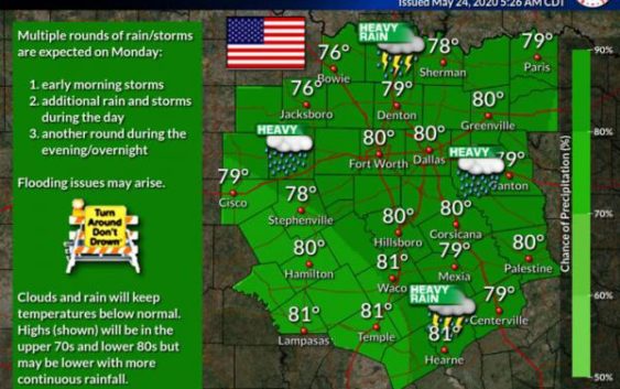
Thunderstorms raging across much of North Texas on Sunday afternoon are expected to continue building into a near-continuous line of storms, producing flooding, hail and damaging wind gusts, especially west of Interstate 35 in the evening to early overnight hours.
Sunday’s storms are capable of dumping large amounts of rain in a short period of time. That means certain locations could flood fast, the National Weather Service says, especially in urban areas and other places with poor drainage.
Memorial Day on Monday will be a wet one, too. Expect more heavy rain, with possible flooding in some areas. The clouds and rain will likely keep temperatures no higher than upper 70s/lower 80s.
Pea sized hail falling in Lewisville, Texas right now. #DFWwx #Lewisvillewx— Joseph (@Joseph_Gates_TX) May 24, 2020
The NWS reminds motorists not to take a chance driving through flooded areas.
@NWSFortWorth #dfwwx receiving occasional pea to dime size hail in rural Waxahachie just west of I35.— D Scruffy1 (@d_scruffy1) May 24, 2020
Some small hail in Plano as a few pop up storms pass. A few storms this afternoon could turn severe with large hail & damaging winds. #dfwwx #txwx pic.twitter.com/n9b3qJDR04— Logan Shipley (@LoganShipleyWx) May 24, 2020
Copyright 2020 KERA. To see more, visit KERA.9(MDAwMTM1NDgzMDEyMzg2MDcwMzJjODJiYQ004))