- 'A little emotional': Hurricanes equipment manager got seconds in goal, memory to last a lifetime
- WMO retires three hurricane names after devastating 2024 season
- Beryl removed from future hurricane naming lists
- Hurricane names Helene, Milton and Beryl are now retired
- Hurricane Helene's name retired after deadly 2024 impact on US
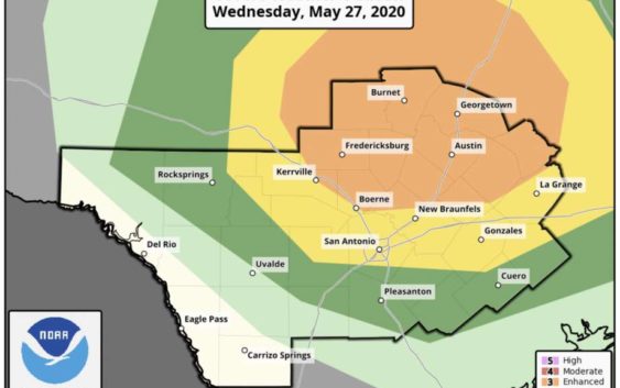
Another round of severe weather possible for SA
-
Strong to severe weather possible in San Antonio on Wednesday.
Strong to severe weather possible in San Antonio on Wednesday.
Photo: Courtesy NWS
Strong to severe weather possible in San Antonio on Wednesday.
Strong to severe weather possible in San Antonio on Wednesday.
Photo: Courtesy NWS
San Antonio may experience another round of severe weather. Thunderstorms are possible Wednesday, especially in areas north of San Antonio.
Currently, a low pressure system is spinning over Texas. By tomorrow afternoon, however, a cluster of thunderstorms could develop and move toward San Antonio.
For Wednesday afternoon, the city is under a slight risk for severe weather, including hail and damaging winds. On Wednesday night, the storms could become stronger with a possibility for tornado activity.
Teresa Velasco is a digital producer for mySA and the San Antonio Express-News. She has a bachelor’s degree in broadcast meteorology. She uses data provided by the National Center for Atmospheric Research, the National Oceanic and Atmospheric Administration and others for her forecasts.