- After Hurricane Beryl, Texas lawmakers push for generators at senior living facilities
- 20-million-gallon detention basin in Meyerland designed to help prevent flooding
- Firefighters report significant progress on McDowell County wildfire
- How to watch the FireAid benefit concert for LA wildfire relief
- FireAid, a benefit for LA wildfire relief, is almost here. Here’s how to watch and donate
Severe weather likely this afternoon elevates flash flood risk

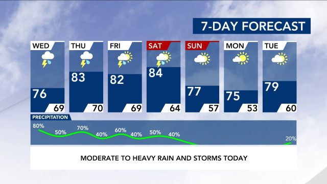
Moderate to heavy rain could move in after lunchtime Wednesday, and two more inches of rain could fall throughout the week, putting some communities at risk for flooding.
It’s very unlikely that a coastal low pressure system offshore near Myrtle Beach, South Carolina, will become a named system, according to WRAL meteorologist Zach Maloch. Even if it doesn’t form, the system will bring heavy to moderate rain and some severe storms to North Carolina starting Wednesday.
The region is under a level 1 risk for severe weather Wednesday, with rain and storms likely to move in this afternoon and evening. WRAL meteorologist Elizabeth Gardner said we could see heavy rain after lunchtime, and isolated tornadoes will be possible.
Much of central North Carolina is under a level 1 risk for severe weather both Wednesday and Thursday.
Rain will continue falling Thursday, Friday and Saturday, tapering off early Sunday morning. The rain will be on and off or scattered at times.
Track the rain with WRAL’s iControl Interactive Doppler Radar
“Right now, rain totals from now through Sunday morning can range between 1 to 3 inches with some locally higher amounts up to 4 inches,” Maloch said.
Johnston, Cumberland, Halifax, Moore and Chatham counties are under a flash flood watch.
Since it has been several days since last week’s downpours, river heights are lowering and approaching their normal levels, but there is still a risk of flooding in some areas.
Jordan Lake’s water level is higher than normal, already flooding a parking lot and causing damage to a boat ramp. Kerr Lake is 12 feet above normal. Falls Lake has rapids racing out of the dam.
“We should be fine in regards to the long-term flood threat, but due to high rain rates, flash flooding will have to be watched through the week,” Maloch said.


