- 'A little emotional': Hurricanes equipment manager got seconds in goal, memory to last a lifetime
- WMO retires three hurricane names after devastating 2024 season
- Beryl removed from future hurricane naming lists
- Hurricane names Helene, Milton and Beryl are now retired
- Hurricane Helene's name retired after deadly 2024 impact on US
Tropical Storm Bertha forms off SC coast, will bring heavy rain to North Carolina

Tropical Storm Bertha has formed off the coast of Charleston, South Carolina, and will bring heavy rain to North Carolina Wednesday and Thursday.
Tropical storm warnings were in place along South Carolina’s coast, but North Carolina will mainly see heavy rain from the storm. Locally, the heavy rain could lead to flooding, and Moore and Chatham counties are under a flash flood watch until Thursday afternoon.
North Carolina could see widespread rain by lunchtime, and there will be a rip current risk along the coast.
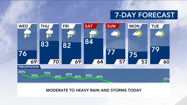
According to WRAL meteorologist Elizabeth Gardner, moderate to heavy rain and severe weather, including isolated tornadoes, could move into central North Carolina Wednesday afternoon, and two more inches of rain could fall throughout the week, putting some communities at risk for flooding.
Much of central North Carolina, from the Triangle south, is under a level 1 risk for severe weather both Wednesday and Thursday.
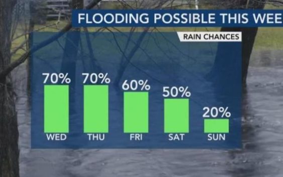
Rain will continue falling Thursday, Friday and Saturday, tapering off early Sunday morning. The rain will be on and off or scattered at times.
Track the rain with WRAL’s iControl Interactive Doppler Radar
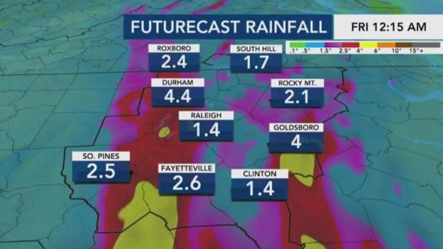
“Right now, rain totals from now through Sunday morning can range between 1 to 3 inches with some locally higher amounts up to 4 inches,” Gardner said.
Moore and Chatham counties are under a flash flood watch.
Since it has been several days since last week’s downpours, river heights are lowering and approaching their normal levels, but there is still a risk of flooding in some areas. Jordan Lake’s water level is higher than normal, already flooding a parking lot and causing damage to a boat ramp. Kerr Lake is 12 feet above normal. Falls Lake has rapids racing out of the dam.
“We should be fine in regards to the long-term flood threat, but due to high rain rates, flash flooding will have to be watched through the week,” Maloch said.

