- Seven months after Hurricane Helene, Chimney Rock rebuilds with resilience
- Wildfire in New Jersey Pine Barrens expected to grow before it’s contained, officials say
- Storm damage forces recovery efforts in Lancaster, Chester counties
- Evacuation orders lifted as fast-moving New Jersey wildfire burns
- Heartbreak for NC resident as wildfire reduces lifetime home to ashes
Level 1 risk for severe weather in effect as chance for storms continue into Friday
Parts of the Triangle westward will continue to be under a level 1 risk for severe weather for the rest of the day Thursday.
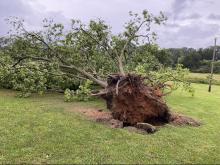
The entire state has a chance of thunderstorms. Durham, Orange, Chatham, Moore, Lee, Person and Granville counties could see the most damaging rain and wind gusts. The storms Thursday and Friday won’t be as powerful as what residents saw Wednesday, when there were two tornado warnings, including an EF-0 tornado that touched down in Warren County.
Halifax County has a flood warning in place until further notice. On Friday, the Lower Roanoke River near Scotland neck is expected to rise above flood stage at midnight and rise near 30 feet by Sunday morning. If the river reaches 31 feet high, then there is widespread flooding on the bank, according to the National Weather Service.

First thing Friday morning there will be waves of rain rolling through. The threat for rain and storms decreases in the Triangle, though Person, Granville and Vance counties will be under a level 1 risk.
Both Friday and Saturday will be hot and humid, with highs in the low 80s and scattered showers.

Sunday will be dry, less humid and pleasant, with a high in the upper 70s.