- NC Gov. Stein pledges continued Hurricane Helene recovery support in 100-day address
- Austin adopts new map that greatly expands area at risk of wildfire
- CenterPoint Energy accelerates infrastructure improvements ahead of hurricane season
- Carolina Hurricanes playoff tickets go on sale Thursday
- Ask the Meteorologist: Why do tornadoes target Tornado Alley, Dixie Alley?
Tropical Depression Three has formed on the first day of hurricane season
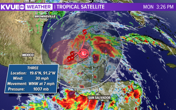
As the 2020 season officially opens, a new storm churns over the Yucatan peninsula.
AUSTIN, Texas — The month of June normally brings a quieter yet modestly active time in the weather department to Central Texas. As we begin the month, a few isolated showers and storms can be expected as we monitor the track of a low-pressure disturbance near the Texas-Mexico border.
Additionally, June 1 is the official beginning of the Atlantic hurricane season. So far in 2020, we’ve had our first two named storms: Arthur and Bertha. Our next named storm to come would be Cristobal.
As of 4 p.m. Monday afternoon, the information from the National Hurricane Center shows a large area of unsettled weather which are remnants of an earlier Pacific tropical storm, Amanda. The disturbance is off of the coast of the Yucatan Peninsula and has formed into Tropical Depression Three. It is forecast to become Tropical Storm Cristobal in the next 24 hours.
The forecast is for the storm to move into the middle of The Gulf of Mexico this weekend. It is too soon to forecast whether the track eventually brings it near the Lone Star state; however, continuous tracking and monitoring will continue as the week wears on.
Here’s a look at this week’s rain chances.
The Climate Prediction Outlooks eight to 14-day look continues to keep rainfall chances at a minimum leading towards a drier and warmer for two weeks.
PEOPLE ARE ALSO READING: