- Researchers forecast 1 major Gulf hurricane in 2025 season
- NC State forecasts near-average Atlantic hurricane season
- Timeline: Texas cold front brings hail, heavy rainfall risk to major cities
- Evacuation order issued as crews battle wildfire in McDowell County
- NC Gov. Josh Stein outraged by attack on PA governor, focuses on Hurricane Helene recovery
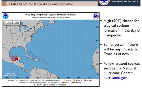
Tropical disturbance likely to develop in Gulf of Mexico to begin official start of hurricane season
-
The National Weather Service said a potential tropical disturbance will “certainly be something to keep an eye on the next few days.”
The National Weather Service said a potential tropical disturbance will “certainly be something to keep an eye on the next few days.”
Photo: National Weather Service
The National Weather Service said a potential tropical disturbance will “certainly be something to keep an eye on the next few days.”
The National Weather Service said a potential tropical disturbance will “certainly be something to keep an eye on the next few days.”
Photo: National Weather Service
Right on cue, a tropical cyclone is likely to form in the Gulf of Mexico as the 2020 Atlantic hurricane season officially begins. The season has already had a busy start, with two named storms – Arthur and Bertha – developing in May.
Now coastal residents near the Gulf of Mexico are anxiously watching a gathering storm, to be named Cristobal, which is likely to sprout soon.
Already the National Hurricane Center has estimated an 80% likelihood of a maturing tropical wave intensifying into a tropical depression or storm, with a clustering of heavy downpours and thunderstorms visible on satellite imagery anchored over Mexico’s Yucatán Peninsula.
The accelerated start to the season is in keeping with the active hurricane season that experts across the board are predicting.
The official outlook from the National Oceanic and Atmospheric Administration (NOAA) calls for a 60% likelihood of an above-average season, with a 70% chance of 13 to 19 named storms, six to 10 of which will become hurricanes. Three to six of those could become major hurricanes of Category 3 intensity or higher, and there is a chance that the season will become “extremely active,” the agency said May 21. Leaders from NOAA and the Federal Emergency Management Agency briefed President Donald Trump on the seasonal forecast last week.
In addition to NOAA’s outlook, atmospheric scientists at Colorado State University have estimated a well above-average season, ascribing a 70% likelihood that a major hurricane will strike somewhere along the Lower 48 in 2020.
The instigating system that bears watching already has a deadly history. A disturbance in the eastern tropical Pacific was named Tropical Storm Amanda on Sunday, making landfall in Guatemala with heavy rain contributing to landslides only three hours later. At least 15 were killed by the storm in El Salvador, including five children. Nearly 19,000 families have been affected, with some 2,000 people relocating to area shelters during the storm.
A red alert was in effect across El Salvador early Monday, issued only when danger reaches a “critical level.”
The system’s remnants crossed the continental divide, weakening some as they traversed the higher terrain. While no longer considered a tropical storm, the circulation is likely to regain tropical storm strength upon emerging over the milder waters of the Bay of Campeche.
Since it’s entering a new ocean basin – and because the system did not continuously maintain tropical storm strength during its transit – it will earn a new name from the Atlantic list. Cristobal is up next, to be assigned if and when the fledgling system’s core winds reach 39 mph.
The system’s unusual movement – first easterly before curving to the north and eventually northwest – is owed to its interaction with a Central American Gyre. That term is used to describe a broad counterclockwise atmospheric circulation over the tropics. Sometimes, Central American Gyre events can enhance the spin a system needs to strengthen. Other times, as in this case, it can influence the steering of a system already in progress.
The system should traipse around north and northeast of Tabasco, Mexico through Tuesday, drifting north over toasty ocean waters in an environment with relaxed upper-level winds supportive of its development. A tropical depression or tropical storm is likely to form by late Tuesday or very early Wednesday.
There is a remote chance that the system scoots a bit farther inland into Mexico and, removed from its heat source, is precluded from developing further. That appears unlikely.
“Ex-Amanda is going to be a heavy rain threat to Mexico, even if it never redevelops in the Bay of Campeche,” wrote CWG’s tropical weather expert Brian McNoldy in an email. “At this point it looks quite robust on satellite images, and it will likely organize further as it heads generally westward.”
From there, uncertainty grows. Some models begin tracking the incipient cyclone northward through the Gulf, while other indications suggest that its interaction with the Central American Gyre could cause it to linger and stall for an extra day or two before shuffling north. In either case, it could ultimately spell U.S. impacts by late week into the weekend.
“The whole Bay of Campeche region is a soup of fairly conducive ingredients right now,” wrote McNoldy. “The exact path forward for any individual system is not very clear-cut . . . but something should come out of it.”
If it does ultimately set its sights on the American Gulf Coast, which appears increasingly probable, it is unlikely to be a major wind maker. Instead, tropical downpours and torrential flooding would be among the greatest impacts. Water is the deadliest threat from tropical cyclones, including storm surge flooding and inland rains.
However, at more than a week out, providing any specific details regarding the low-confidence forecast is impossible. However, the forecast warrants all residents living along the Gulf of Mexico to pay close attention and prepare for possible impacts. Planning is complicated this year due to the coronavirus pandemic, which could limit the use of storm shelters and alter typical steps involved in tropical storm and hurricane response efforts.
– – –
The Washington Post’s Andrew Freedman contributed to this report.