- National memorial to honor NC firefighter who died on duty during Hurricane Helene
- Gov. Josh Stein extends State of Emergency for western NC wildfires
- Gov. Stein extends state of emergency for NC wildfire threat
- Governor Stein extends state of emergency for NC wildfire threat
- Governor Stein extends emergency in 34 NC counties amid wildfire threat
Houston's weekend weather depends on Tropical Storm Cristobal's track
-
The National Weather Service’s wind speed probabilities map for Wednesday, June 3, 2020 at 4 a.m.
The National Weather Service’s wind speed probabilities map for Wednesday, June 3, 2020 at 4 a.m.
Photo: National Weather Service
The National Weather Service’s wind speed probabilities map for Wednesday, June 3, 2020 at 4 a.m.
The National Weather Service’s wind speed probabilities map for Wednesday, June 3, 2020 at 4 a.m.
Photo: National Weather Service
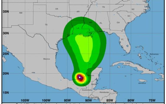
As forecasters continue to watch Cristobal’s development near southern Mexico on Wednesday, Houston is in for another day of heat, according to the National Weather Service.
Cristobal is expected to make landfall into southern Mexico in the next 24 hours, NWS Houston/Galveston reports this morning. The storm is expected to weaken, then move north toward the central Gulf on Friday.
HURRICANE TIPS: Readers share their best hurricane preparation advice
The latest track shows Cristobal moving toward the central Gulf Coast late Sunday into Monday, but forecasters warn that the future track and intensity of the storm is still very uncertain.
Clouds will increase across Houston Wednesday, with a chance of showers and thunderstorms in some areas. High temperatures are expected in the upper 80s and lower 90s. “Any activity that does develop should dissipate by around sunset and not much development is expected tonight.”
Even warmer temperatures are expected Thursday, Friday and Saturday. Daytime highs could be in the mid-90s, with heat index near triple digits, the NWS states.