- One set of evacuation orders lifted in Caldwell County after wildfire contained
- 'We gutted every building' | Chimney Rock rebuilding after Hurricane Helene
- 'We gutted every building' | Chimney Rock rebuilding after Hurricane Helene
- Debris from Hurricane Helene provides fuel, complicates containment for spring wildfires
- David & Nicole Tepper increase Hurricane Helene relief commitment to $750k
Heavy rain, flash flood threat comes this afternoon, evening along and east of I-95
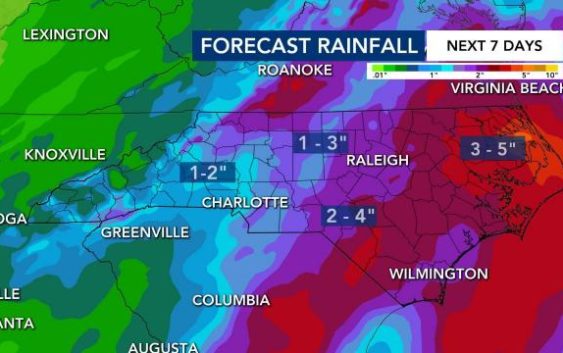
Central North Carolina is under a level 1 risk for severe weather Thursday, with showers and storms increasing in intensity through the afternoon and early evening. Up to 3 inches of rain could fall through midnight, with the greatest impact coming along and east of Interstate 95.
Track the rain with the DualDoppler5000
Storms popped up before noon in the Sandhills, where thunder and lightning were reported near Dunn.
“As this system moves east, it will become stronger,” WRAL metorologist Elizabeth Gardner said.
The slow-moving rain could bring isolated flooding. “The cells will not move very quickly and could produce a lot of heavy rain,” Gardner said.
The entire viewing area, including the Triangle, is under a flash flood watch until 8 a.m. Friday.
There is an 80% chance for rain across central North Carolina through about 9 p.m., with rain still likely through mid-morning on Friday.
Some storms could be severe Thursday afternoon and evening, with the main threat being wind damage. Gardner said..
Get WRAL severe weather alerts on your device.
On Friday, scattered rain will continue in the Triangle and to the east through the morning as the front moves away. The afternoon should be mostly dry, and highs will be milder again, in the low 80s.
Gardner said some rain is in the forecast each day for the next seven days, although it won’t be as heavy as Thursday’s. On Saturday, isolated rain and storms will be around the area midday and afternoon, although not everyone will see rain.
Cooler-than-usual temperatures and scattered thunderstorms are in the forecast all next week as an upper level low pressure system stalls directly over North Carolina.
Highs will be in the low 80s all weekend, and early next week could see some highs in the upper 70s.
