- Sellers and Rantanen are among the NHL trade deadline winners. Hurricanes and Boeser are some losers
- Hurricane forecasters express concern over NOAA job cuts impact
- FEMA deadline for Hurricane Helene recovery aid extended again
- Tornado drills to take place at schools across North Carolina Friday morning
- Hays County emergency alerts cause confusion during Tuesday's wildfires
Level 2 severe weather threat: Rain pummels Chapel Hill as storms begin popping up in the Triangle
Raleigh, N.C. — Southern parts of the Triangle are under a level 2 threat for severe weather, while northern areas are under a level 1 risk. Rain began pummeling Chapel Hill as storms popped up around the Triangle around 5 p.m.
Damaging winds and heavy downpours are the main threat with these storms, as a cold front passes across North Carolina.
The threat for damaging winds is possible for central North Carolina all the way to the coast.
While we need to be on the look out for damaging winds, tornadoes are not threat for Sunday.
“As we get into the afternoon, at 4 o’clock, we’ll see some scattered thunderstorms develop. Then it’ll turn quieter as we head into the second half of the evening,” WRAL meteorologist Aimee Wilmoth said.
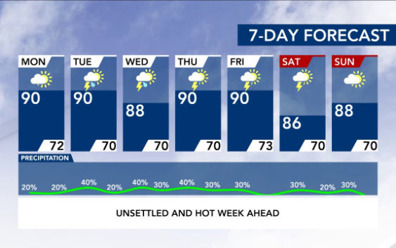
Sunday’s storms are likely to linger until Monday morning. Despite the cold front passing over, Monday will not be cooler than Sunday. Temperatures will reach 90 degrees.
The forecast for the week ahead looks warm and stormy, with temperatures hovering in the high 80s or early 90s, and potential for storms each day.
On top of all that, the Sahara dust that’s moved into our area has created an air quality alert. It’s in effect for the entire viewing area from 6 a.m. to 9 p.m. on Sunday. It is a code orange event, which means people with breathing problems may struggle when outside.