- As city leaders consider expanding at-risk zone for wildfire damage, home builders say it could raise costs
- Is your neighborhood at high wildfire risk? | Here's how to check the city's wildfire risk map
- 'Be prepared now': Brad Panovich updates severe weather risk for Sunday
- 'Be prepared now': Brad Panovich updates severe weather risk for Sunday
- As anxiety around wildfires grows, Austin plans to add tens of thousands of acres to risk map
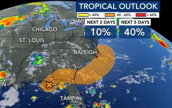
Rain returns, tropical storm could form by weekend
After just scattered thunderstorms on Monday, the chance for rain picks up through the middle of the week.
First, a low pressure system making its way across the southeast will keep the atmosphere unsettled, allowing for a daily chance for thunderstorms.
“It won’t be the greatest pool weather on Tuesday and Wednesday, but the big heat backs off,” said WRAL meteorologist Mike Maze.
The high temperatures stay in the upper 80s through Thursday before a rebound for a warmer weekend.
Through the end of the week, central North Carolina could see up to 2 inches of rain, but those at the coast could see 2-4 inches. Rain will be heaviest Wednesday and Thursday.
Next, the National Hurricane Center shows a surface low that could track across Georgia and South Carolina before developing into a tropical storm off the coast of North Carolina late in the week or next weekend.
“There’s about a 40% chance of this developing into Tropical Storm Faye,” Maze said.
“We’re not concerned at all that it’s going to develop and then ram back into North Carolina bringing winds and rain,” he said.