- Long-term closures begin on I-10 Katy Freeway to elevate road, prevent flooding
- Texas firefighters helping battle California wildfires
- Western NC teams helping both hurricane and wildfire victims
- New wildfire warnings issued and more power is shut off as winds rise in Southern California
- In wake of wildfires, Spurs' Chris Paul, Victor Wembanyama give JJ Redick's sons their game-worn jerseys
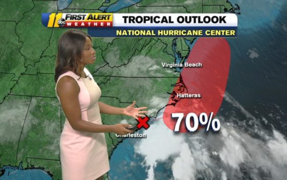
Tropical Storm Fay? System could form off North Carolina coast

Fay?
The low is currently located along the South Carolina coast. It now has a 70 percent chance of becoming a tropical depression or storm soon. The next name of the 2020 list is Fay.
Even it it becomes a named storm, our impacts in central North Carolina won’t change. We’ll continue to see scattered storms and cooler temperatures through Thursday. The area of low pressure will continue moving northeast, away from the North Carolina coast, Friday through the weekend.
RELATED:New 2020 hurricane prediction warns of more named storms
Drier air pushes in Friday lowering rain chances, and heating things up. Highs will reach the low 90.
Cristina
Tropical Storm Cristina formed late Monday night local time in the Eastern Pacific Ocean and is on its way to becoming the first hurricane of the 2020 season in any of the Western Hemisphere ocean basins.
As of Wednesday morning, the storm was located well away from land, about 380 miles south-southwest of Manzanillo, Mexico. It was moving at a speed of 13 mph and featured maximum sustained winds of 44 mph.
Thus far there have been three tropical storms and one tropical depression in the Eastern Pacific basin this year.
Meanwhile the Atlantic has had five tropical storms, and could be on the verge of a sixth-named storm this week.
Neither basin has yet spawned a hurricane, but that is about to change.
AccuWeather meteorologists expect Cristina to become not only the first hurricane of the North and Central American waters, but perhaps the first Category 2 hurricane with maximum sustained winds of at least 96 mph.
Edouard
Tropical Rainstorm Edouard continues to move northeast quickly across the northern Atlantic Ocean. The storm will begin to impact Ireland late Wednesday with locally heavy rainfall and gusty winds.
It will move across England and into the North Sea Wednesday night or early Thursday. Edouard is the earliest fifth-named storm in the Atlantic basin on record (1966-present), breaking the previous record held by Tropical Storm Emily from July 12, 2005.
Copyright © 2020 WTVD-TV. All Rights Reserved.