- Wildfire in San Jacinto Co. grows to 2,000 acres, 10% contained; evacuations in place | Shelters, school closings and more
- Wildfire in San Jacinto Co. grows to 1,300 acres, 10% contained | Several evacuations in place
- Wildfire in San Jacinto Co. grows to 1,200 acres, 10% contained
- Wildfire in San Jacinto Co. grows to 700 acres, zero percent contained
- Wildfire in San Jacinto Co. burns at least 200 acres, zero percent contained
Tropical storm likely to form near NC coast, bringing heavy rain
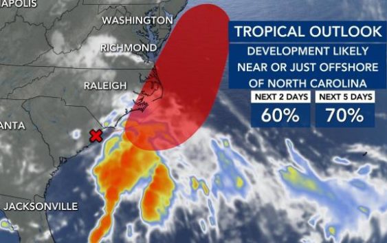
It’s becoming more likely that a tropical storm could develop near North Carolina over the next two days, bringing heavy rain to the coast.
According to the National Hurricane Center, the low pressure system is currently over South Carolina and moving northeast towards the North Carolina coast.
The system is expected to form into a tropical depression or tropical storm near or just offshore North Carolina in the coming days.
WRAL meteorologist Elizabeth Gardner said up to 2 inches of rain are possible over the next five days, with more rain falling east of Interstate 95.
The Triangle will see some heavy downpours in the afternoon and evening Wednesday and Thursday, but severe weather is not expected. A moderate rip current risk is already in effect at the coast and will likely be upgraded to a high risk by Thursday.
Although a risk for storms remains Friday, rain will be heaviest Wednesday and Thursday.
Temperatures will stay mild, with highs in the mid to upper 80s, until the weekend, when sunshine and 90s return.
