- Sellers and Rantanen are among the NHL trade deadline winners. Hurricanes and Boeser are some losers
- Hurricane forecasters express concern over NOAA job cuts impact
- FEMA deadline for Hurricane Helene recovery aid extended again
- Tornado drills to take place at schools across North Carolina Friday morning
- Hays County emergency alerts cause confusion during Tuesday's wildfires
Houston Forecast: Tropical Storm 'Fay' Forms Off The East Coast
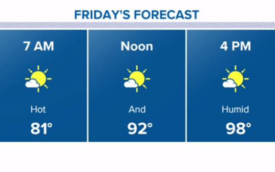
Houston temperatures continue to soar and we could see a 100+ through the weekend..
HOUSTON — Ready, set, sweat! July is about to show us what it’s made of with our first triple digit heat looking likely this coming weekend.
If you’re looking for any rain relief, there isn’t a single drop in sight; at least for the next 7 to 10 days.
Most importantly, take breaks in the A/C so your body’s core temperature can have a chance to cool down.
While the heat we’re looking at is intense, it’s not even close to record breaking. In fact, all of our record highs this weekend and into next week are almost exclusively from the year 1980, by far one of Houston’s hottest summer’s. We wouldn’t see another one like it until 2011.
A large dome of high pressure is going to build across the southern US and with it shut the rain chances down and crank up the heat. A heat advisory for feels-like temps as high as 113°F is looking likely beginning Friday into the weekend.
Tropics
BREAKING: Tropical Storm Fay has formed off the coast of North Carolina. Advisories will be initiated at 4pm central.
GET ALERTS ON YOUR PHONE: Download the KHOU 11 app
TRACK THE WEATHER: Houston weather radar