- David & Nicole Tepper increase Hurricane Helene relief commitment to $750k
- McDowell County wildfire spreads to 500 acres, evacuation orders in place
- Evacuations in Caldwell County due to wildfire
- Northwest Houston 'ghost neighborhood' caused by repeated flooding to become latest detention basin
- NHL playoffs: Hurricanes open playoffs Easter Sunday afternoon vs. Devils
Tropical Storm Hanna Aims For Corpus Christi And Deep South Texas
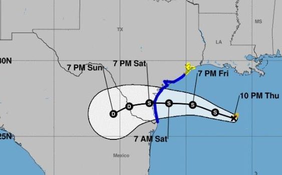
A powerful but disorganized storm system off the Texas Gulf Coast strengthened and swirled into Tropical Storm Hanna on Thursday night and took aim for Corpus Christi and Deep South Texas.
The National Hurricane Center, or NHC, reported at 10 p.m. that Hanna was about 385 miles east-southeast of Corpus Christi and was moving west-northwest at 7 mph. Aircraft sent into the storm measured maximum sustained winds of 40 mph.
Brian Hoeth, an emergency response meteorologist with the National Weather Service in Fort Worth, said the storm was expected to make landfall on Saturday.
“Based on the current storm track,” he explained on Thursday, “lighter amounts are expected to north and south of the storm with one to two inch totals on average and isolated maximum amounts of four inches possible for the Hill Country and San Antonio areas.”
By Thursday night, Hanna’s track had shifted slightly southward as compared to earlier estimates.
Forecasters issued a tropical storm warning from Port Mansfield southward to the mouth of the Rio Grande, which, according to the NHC, means that “tropical storm conditions are expected somewhere within the warning area within 36 hours,” or around Friday night.
A tropical storm watch extended from San Luis Pass to High Island. That means that “tropical storm conditions are possible within the watch area, generally within 48 hours,” or also around Friday night or Saturday morning.
Hoeth said the storm was expected to continue on a westward track across South Texas through Sunday, weakening as it progressed, and dissipate over Mexico on Monday.
A statement from the NHC on Thursday night explained that “Hanna is expected to produce 3 to 5 inches of rain with isolated maximum totals of 10 inches through Monday along the Gulf Coast of the United States from Louisiana to south Texas, and inland to the Mexican states of Coahuila, Nuevo Leon, and northern Tamaulipas.”
It was not yet known if the San Antonio region would benefit from much, if any, of the rain, considering the storm’s updated track, which took it through Deep South Texas. The lack of rain has become all the more serious as water levels in the Edwards Aquifer continue to drop and water restrictions on area residents intensify.
The National Hurricane Center also monitored Tropical Storm Gonzalo, which could reach hurricane strength by late Friday or early Saturday as it entered the eastern Caribbean.
This is a developing story and will be updated soon.
Fernando Ortiz Jr. contributed to this report.
Brian Kirkpatrick can be reached at Brian@tpr.org and on Twitter at @TPRBrian.
TPR was founded by and is supported by our community. If you value our commitment to the highest standards of responsible journalism and are able to do so, please consider making your gift of support today.