- Sellers and Rantanen are among the NHL trade deadline winners. Hurricanes and Boeser are some losers
- Hurricane forecasters express concern over NOAA job cuts impact
- FEMA deadline for Hurricane Helene recovery aid extended again
- Tornado drills to take place at schools across North Carolina Friday morning
- Hays County emergency alerts cause confusion during Tuesday's wildfires
Tropics update: Tropical Depression Eight strengthens to become Tropical Storm Hanna in Gulf of Mexico
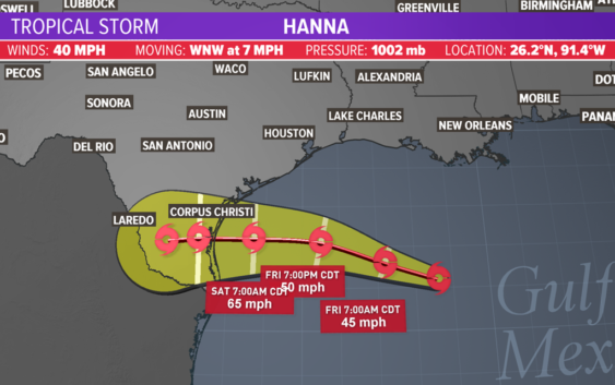
Tropical Depression Eight became Tropical Storm Hanna late Thursday night. It’s is in the Gulf of Mexico and will bring heavy rain to Texas this weekend.
HOUSTON — The KHOU weather team and National Hurricane Center are tracking two tropical systems, one of which is expected to affect Houston-area weather. Tropical Depression Eight formed into Tropical Storm Hanna late Thursday night in the Gulf of Mexico. It’s headed for the Texas coast. Meanwhile, Tropical Storm Gonzalo is picking up steam in the Atlantic.
Get the updates on each below.
Tropical Storm Hanna
This is our primary concern along the Texas coast right now as it is expected to bring several inches of rain. A Tropical Storm Warning is in effect from San Luis Pass to Port Mansfield. That means tropical storm conditions are expected within the next 36 hours.
GET ALERTS ON YOUR PHONE: Download the KHOU 11 app
TRACK THE WEATHER: Houston weather radar
FORECAST: Get the latest Houston weather update
As of the 10 p.m. update, Hanna was named and is headed to the Texas coast at about 10 mph. Upper-level wind patterns are sending the system towards Texas. It will bring an increased rain threat to Southeast Texas on Friday and Saturday.
The storm is projected to make landfall further down the Texas Coast just south of Corpus Christi.
We are not anticipating for it to stall over Texas which would have been troublesome. It will not be as much of a wind threat here in Houston. More of a rain threat but that has started to diminish.
Hanna formed from Tropical Depression Eight, which is pictured below.
We’ll see some additional tropical moisture (rain) come our way across the Houston area, which means more robust and heavier downpours. The timing is from Friday to Sunday. We could see rough waves, gusty winds and torrential rain, bringing with it rain between 1 and 4 inches and localized flooding.
Even though we are out of the “cone of uncertainty,” our 7-day forecast shows plenty of rain for the Houston area, much of it due to this tropical system:
Tropical Storm Gonzalo in Atlantic
The second area that we are tracking is still in the open Atlantic but quickly gaining strength and organization. It became tropical depression seven Tuesday and was upgraded tropical storm status Wednesday.
Satellite data indicated that Tropical Storm Gonzalo had 60 mph winds as of Thursday afternoon, according to the National Hurricane Center. It’s moving west at 13 miles per hour.
It’s still to soon to determine where Gonzalo might head and what impacts it could have in the U.S., if any. Its forecast track has it located south of Cuba by early Tuesday morning.
Some long-range models do take the system towards the Gulf but it’s still too early to know if that’ll occur.