- Sellers and Rantanen are among the NHL trade deadline winners. Hurricanes and Boeser are some losers
- Hurricane forecasters express concern over NOAA job cuts impact
- FEMA deadline for Hurricane Helene recovery aid extended again
- Tornado drills to take place at schools across North Carolina Friday morning
- Hays County emergency alerts cause confusion during Tuesday's wildfires
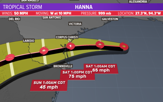
Tropical Storm Hanna expected to become hurricane by tomorrow's landfall

The storm continues to get better organized and is now expected to become a hurricane tomorrow.
HOUSTON — The KHOU weather team and National Hurricane Center are tracking two tropical systems. One is bearing down on the South Texas coast
Tropical Storm Hanna is nearing landfall and is expected to become a hurricane before it does. Hanna is expected to make landfall south of Corpus Christi. Meanwhile, Tropical Storm Gonzalo is expected to dissipate over the next couple days as it moves westward from the Atlantic into the Caribbean Sea.
Get the updates on each below.
Tropical Storm Hanna
Tropical Storm Hanna is bearing down on the South Texas coast. There is a hurricane warning in effect from Baffin Bay to Mesquite Bay. At 10 p.m. Friday, the storm had maximum sustained winds of 65 miles per hour. It continues its westerly track at 8 miles per hour.
Closer to Houston, there is a storm surge warning for Matagorda Island, coastal Jackson County, coastal Matagorda County, coastal Refugio and Coastal Calhoun County.
In Brazoria County, all beaches are closed to vehicles because of extremely high tides.
In Houston, we may only get 1 to 3 inches of rain widespread through the weekend. Closer to the coast, we may get 5 inches of rain. This is an improvement from when the forecast track was farther north, and Houston was in the cone of uncertainty.
The earlier Tropical Storm Watch for areas in Harris and Galveston counties has now been canceled, the National Weather Service in League City says.
Tropical Storm Watches and Warnings are still in effect, however, for parts of the Texas coast farther south heading toward Corpus Christi.
Tropical Storm Gonzalo in Atlantic
The second area that we are tracking is Tropical Storm Gonzalo. It is moving westward out of the Atlantic and into the Caribbean sea.
A first glance at the cone looks like it could be bad news for the Gulf of Mexico, but the National Hurricane Center says Gonzalo is “tiny” and could dissipate over the weekend, making it not a major threat to land at this time.
As of the 10 p.m. update on Friday, Gonzalo had winds of 40 mph and is moving west at 17 mph.