- Sellers and Rantanen are among the NHL trade deadline winners. Hurricanes and Boeser are some losers
- Hurricane forecasters express concern over NOAA job cuts impact
- FEMA deadline for Hurricane Helene recovery aid extended again
- Tornado drills to take place at schools across North Carolina Friday morning
- Hays County emergency alerts cause confusion during Tuesday's wildfires
Tropical Storm Isaias forms in Atlantic, could hit NC on Monday
The National Hurricane Center announced on Wednesday that Tropical Storm Isaias has formed in the Atlantic.
As of Thursday morning, the storm was 200 miles southwest of the Dominican Republican. It was moving at 10 miles per hour with winds at 50mph.
It should make landfall around Saturday or Sunday and hit North Carolina by Monday. We will likely feel the effects then, though the models are not exactly clear on its path just yet.
North Carolina is in the path of Tropical Storm Isaias. We will likely feel the effects of the storm on Monday.
It is the earliest “I-named storm” on record, according to The Associated Press.
The storm is currently around 1,500 miles from Raleigh, meteorologist Kat Campbell reported Wednesday night.
“There’s still a lot of uncertainty with this system,” Campbell said. “We have seen a significant shift in the models (Wednesday).”
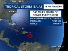
The storm had maximum sustained winds of 50 mph and was positioned about 155 miles south of Ponce, Puerto Rico. It was heading west northwest at 20 mph.

The NHC also reported late Wednesday the government of the Bahamas had upgraded the tropical storm watch for the Central Bahamas to a tropical storm warning. A tropical storm watch is also in effect for the Northwestern Bahamas.
There a few things meteorologist are watching with this storm system:
- Ocean temperatures: tropical wave has enough moisture to keep some organization
- Dry air to the north: might slow development