- Seven months after Hurricane Helene, Chimney Rock rebuilds with resilience
- Wildfire in New Jersey Pine Barrens expected to grow before it’s contained, officials say
- Storm damage forces recovery efforts in Lancaster, Chester counties
- Evacuation orders lifted as fast-moving New Jersey wildfire burns
- Heartbreak for NC resident as wildfire reduces lifetime home to ashes
National Hurricane Center reports Isaias now Category 1 hurricane, could brush N.C. coast

Raleigh, N.C. — The National Hurricane Center reports what was Tropical Storm Isaias is now a Category 1 hurricane.
A special advisory was issued after 11 p.m. after a hurricane hunter plane that was traveling into the storm picked up hurricane-force winds. The storm is now listed at 80 mph just after midnight on Friday. It was 80 miles southeast of the Great Inagua Island in the Bahamas. It was moving northwest at 18 mph.
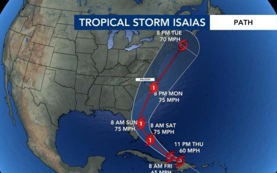
The Thursday 11 p.m. update from the National Hurricane Center has the storm maintaining 60 mph winds. The current path of the storm has it impacting the North Carolina coast as early as Monday morning with the threat continuing into early Tuesday before heading out to sea.
Flooding would be the biggest risk with the storm, mainly at the coast. Impacts from the storm would be between Monday and Tuesday.
There is a threat for rip currents starting Friday. Meteorologist Kat Campbell said there will be a high rip current risk from Wilmington to Ocracoke Island. A moderate rip current threat will be in effect north of Ocracoke Island and south of Wilmington.
The storm could be upgraded to a Category 1 Hurricane on Saturday while it is in the Bahamas. A Tropical Storm Watch was issued Thursday afternoon for parts of the Florida coast. There is a risk for storm surges, heavy rain and winds along the Florida coast this weekend.
On Thursday, Tropical Storm Isaias was headed toward the Dominican Republic at 21 mph as a strong tropical storm. The National Hurricane Center said Tropical Storm Isaias will produce heavy rain, flash-flooding and mudslides across Puerto Rico, the Dominican Republic, northern Haiti, Turks and Caicos and the Bahamas on Friday.
On Saturday, hurricane conditions and storm surges are expected in the Bahamas.
The storm is currently around 1,000 miles away from Wilmington.
Meteorologist Kat Campbell says winds are forecasted to be about 75 mph if the storm brushes the Outer Banks.
In the Dominican Republic, Tropical Storm Isaias would move through mountainous terrain, which can “tear apart” tropical systems, according to WRAL meteorologist Zach Maloch.
But water temperatures are warm, and there is plenty of moisture in the atmosphere, which will help this system grow, Maloch said.
The path of the storm will ultimately determine its intensity, he said. If it stays over open water, it will gain strength. But if the storm’s path is over land, it will not been as intense.
Isaias is the earliest “I-named storm” on record, according to The Associated Press.
There a few things meteorologist are watching with this storm system:
- Ocean temperatures: tropical wave has enough moisture to keep some organization
- Dry air to the north: might slow development
Central North Carolina has a chance of storms every afternoon this week.