- National memorial to honor NC firefighter who died on duty during Hurricane Helene
- Gov. Josh Stein extends State of Emergency for western NC wildfires
- Governor Stein extends state of emergency for NC wildfire threat
- Governor Stein extends emergency in 34 NC counties amid wildfire threat
- Texans can buy emergency preparation supplies tax-free April 26-28 ahead of severe weather season
Isaias expected to strengthen, make landfall near Myrtle Beach as a hurricane
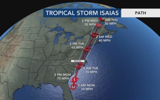
Raleigh, N.C. — Tropical Storm Isaias is expected strengthen into a hurricane before it makes landfall near Myrtle Beach overnight Monday and into Tuesday.
Isaias could make landfall near the South Carolina-North Carolina line Tuesday after midnight with top winds of 75 mph.
The 5 a.m. update from the National Hurricane Center shows little change to its path but indicates it will become a weak hurricane prior to landfall.
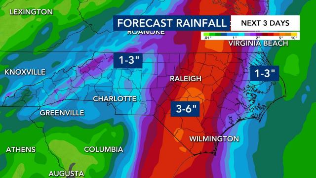
Rainfall totals up to 3 to 6 inches are expected in the Triangle but more so along the Interstate-95 corridor, with isolated amounts of 8 inches possible. Bands of rain from the storm could reach the Triangle by lunchtime, but the greatest impacts are expected between midnight and early Tuesday afternoon.
Because of the storm’s westerly track, rain and impacts will be heaviest in the Sandhills, not at the coast.
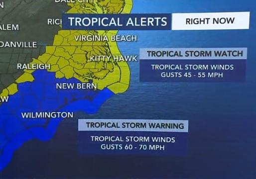
“I believe along and east of the track which carries the center through Sampson, Wayne and Edgecombe counties, there could be winds gusting 60 to 70 mph,” said WRAL meteorologist Mike Maze.
According to Maze, while Isaias will bring heavy rain, it will not be a repeat of Matthew, Florence or Floyd, which all produced double-digit rainfall totals.
Resources: Interactive Hurricane Tracker | Webcams | Get WRAL alerts | Know your flood risk
“There will be flash flooding and perhaps moderate river flooding on the Neuse at Clayton and Smithfield, but right now there is no indication of river flooding for the Tar and Cape Fear,” Maze said.
See all alerts here and subscribe to get WRAL Weather updates on your device.
Three coastal counties — Brunswick, New Hanover and Pender — are now under a hurricane watch as Isaias moves closer to North Carolina. A hurricane watch means hurricane-force winds are possible within the next 48 hours.
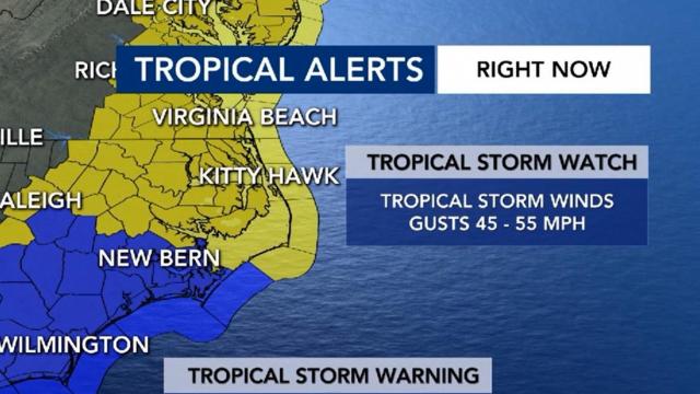
Several other counties in North Carolina are under a tropical storm watch and flash flood watch. Communities in the watch area can expect 3 to 6 inches of rain, wind gusts up to 70 mph and a chance for isolated tornadoes after midnight and Tuesday morning.
Cumberland, Johnston and Sampson counties have been upgraded to a tropical storm warning until further notice. Those communities in the warning area can expect tropical storm force winds within the next 36 hours.
We can expect some damage to roofs and mobile homes, as well as downed trees and power outages. Some bridges and roads may be blocked from downed trees as the storm approaches.
A Flash Flood watch is also in effect for Central North Carolina and the coast.
Tropical Storm Isaias track has shifted a little to the east. WRAL meteorologist Mike Maze says projected landfall will be around South Carolina and North Carolina Monday after midnight.
There storm will have top winds of 70 mph.
Maze says there’s still a potential it could become a weak hurricane prior to landfall.
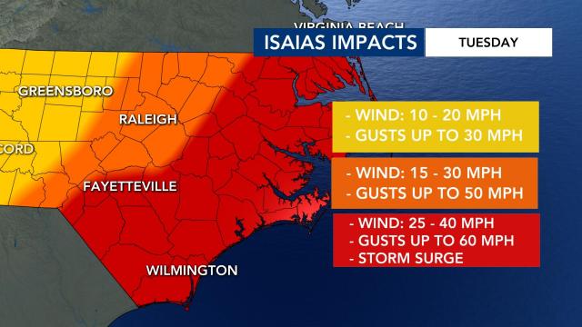
“For NC this is shaping up to be as much a wind event as a rain event,” said Gardner. “The storm will move through NC very quickly with gusts from Raleigh eastward anywhere from 50 to 70 mph. This will knock down trees and cause power outages.”
Tropical Storm Isaias is moving quickly, which should help keep the rain totals down. This is not expected to cause major flooding like Florence or Matthew; however, there will be some flash flooding and the Neuse, Cape Fear and Tar rivers could rise to moderate or even major flood stages briefly.
Tropical Storm Isaias’ path
At 4:30 a.m. Monday, Tropical Storm Isaias was about 300 miles from North Carolina’s coast.
At 8 p.m. Monday, the storm will be nearing South Carolina’s coast. After that, the latest models predict that landfall is possible along the South Carolina line near Brunswick County beaches — including Sunset Beach, Holden Beach and Ocean Isle.
As a result, a hurricane watch has been issued from South Carolina to Surf City, but that could be upgraded to a hurricane warning sometime Monday.
Models show the storm will move up the I-95 corridor after it makes landfall. This means, WRAL meteorologist Elizabeth Gardner said, that the storm won’t be as big of a deal for the Outer Banks, which are usually hit by storms hard.
“The impact will be greatest right here in the Triangle,” Gardner said.
Isaias is expected to impact central North Carolina to the coast Tuesday morning into the early afternoon. “This is a fast moving storm,” Gardner said. “By 8 p.m. Tuesday, the storm will be in New York City.”
Coastal area evacuations and closings
In Hyde County, commissioners ordered any visitors to the leave Ocracoke Island by Saturday at 6 a.m.
Mandatory evacuations for renters, vacationers and guests in Holden Beach was declared Friday. The evacuation is in effect as of 7 p.m. Saturday. Ocean Isle Beach is also closing its beaches at noon on Saturday for non-residents.
Cape Hatteras National Seashore will also be closed on Sunday for Isaias.
“If you’re ordered to evacuate, we want you to evacuate. Consider staying with family and friends,” Cooper said. “Try to get a hotel. We do not want people to stay if there is an evacuation order in place.”
Hurricane Isaias impacts so far
Hurricane Isaias made landfall in the Bahamas as a Category 1 hurricane with 80 mph sustained winds earlier Saturday. The coast of Florida is seeing strong winds and showers from the rain.
“Now is the time for North Carolinians to prepare,” Gov. Roy Cooper said Friday in outlining how emergency management leaders would plan a response to Hurricane Isaias.
Saturday afternoon, Cooper announced that up to 150 members of the North Carolina National Guard were being activated to be used if needed in hurricane preparation. Water rescue teams are also preparing to respond, if needed.
If Isaias misses Florida, we will likely see a stronger storm system hit the North Carolina coast. If Isaias does hit Florida, we will likely get a tropical storm and feel impacts in more of the central parts of North Carolina.
Sheltering ‘a last resort’ during a pandemic
Gov. Roy Cooper and State Director of Emergency Management Mike Sprayberry said, due to COVID-19, shelters should be a last resort for people who need to leave their homes.
“If you live at a safe place inland, please do your part and offer to let family or friends evacuate to your home,” Sprayberry said.
Shelters will screen evacuees for COVID-19 symptoms.
“If they have symptoms, then they’re going to be sent somewhere to be isolated, depending on their condition,” Sprayberry said. “It could be a hotel, it could be a medical facility.”
The state had prepared Sandhills Regional Medical Center in Hamlet to handle a surge of coronavirus patients, Sprayberry said, and that would be called into service should it be necessary as a medical shelter.
Cooper has activated up to 150 National Guard soldiers to help with preparations. Several water rescue teams are ready to support impacted communities, and PPE is being provided to our responders to enable them to operate within a COVID-19 environment.
Officials encouraged the public, saying North Carolina is as prepared as ever for the storm, “But this time we’re going to have to do it with a mask on.”
Emergency officials said to check ReadyNC.org for complete list of items that should be included in an emergency kit.
The Red Cross needs young people like college students to help as volunteers.
Be prepared for severe weather
Residents are urged to prepare for possible heavy rain, high wind and power outages by:
- Securing loose outdoor furniture and decorations that may fly away in strong winds.
- Preparing an emergency kit with non-perishable food, bottled water and enough medication for three days.
- Charging cell phones and filling up gas tanks.
- Having cash on hand in case of power/internet outages. Stores, including gas stations, may not be able to accept credit card payments in the event of power/internet outages.
- Advice from Raleigh storm victim: Take photos of belongings
