- Severe storms, flooding make mess for drivers on the road Sunday
- ‘The safety and well-being of Texans is our No.1 priority’ | Gov. Abbott announces federal aid for resources to fight Texas wildfires
- Crabapple wildfire near Fredericksburg increases to 9,500 acres, still only 40% contained
- Fire crews continue to battle 9,500-acre wildfire near Fredericksburg
- Power outages: Widespread impacts in NC mountains after severe weather outbreak
Tropical Storm Isaias expected to make landfall Monday night with dangerous winds and storm surge
RALEIGH, N.C. (WTVD) — Tropical Storm Isaias is strengthening and speeding up. It is expected to be a Category 1 hurricane when it makes landfall with dangerous winds and storm surge in the Carolinas late Monday night or early Tuesday morning.
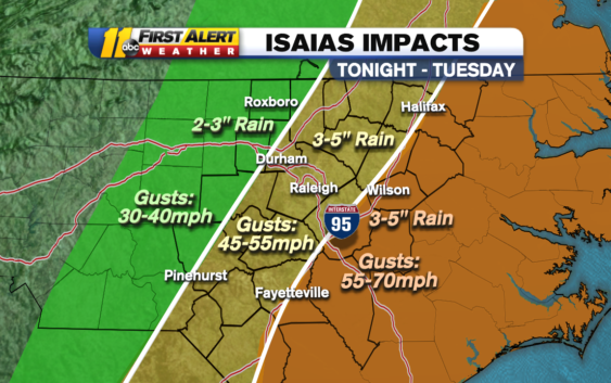
Currently, forecasts show the storm’s outer bands impacting the Sandhills between 11 p.m. and 12 a.m., then hitting the Triangle between 2 and 4 a.m. Isaias will move into northern North Carolina and Virginia between 4 and 5 a.m.
The strongest winds and heaviest rains will arrive after midnight and be gone by 8 a.m.
A tornado watch is in effect for Sampson county until 2am. More counties will likely be added to this watch later tonight. The threat for a brief spin up tornado is highest along and east of the I-95 corridor. pic.twitter.com/V8jIHmxxeg
— Brittany Bell (@BrittanyABC11) August 3, 2020
As of 5 p.m., the storm was 120 miles south southwest of Myrtle Beach and maximum sustained winds were near 70 mph with higher gusts.
Some strengthening is forecast later Monday afternoon or early evening and Isaias is expected to make landfall Monday night at or near hurricane strength along the coast of northeastern South Carolina or southern North Carolina.
Only gradual weakening is anticipated after Isaias makes landfall in the Carolinas and moves across the U.S. mid-Atlantic region Monday night and Tuesday.
Stay up-to-date with the latest information on the storm by downloading the ABC11 app
Tropical Storm Warnings are in effect for areas as far west as Wake County as well as along and east of the Interstate 95 corridor. Warnings are issued when winds of 39 to 73 mph are expected in the region within the next 36 hours. A Hurricane Warning has been issued for New Hanover and Brunswick counties.
TIMING
Scattered storms are possible all Monday afternoon, but the first main line from Isaias will enter the Sandhills area around 8-10 p.m. Monday.
Late Monday into early Tuesday, central and eastern North Carolina can expect heavy rain and flash flooding.
Isaias is now moving at 13 miles per hour, meaning the heaviest of the rain should be moving out of the state by 9 a.m. Tuesday.
When it’s all said and done, rain totals could be between 3 and 6 inches. Winds will likely be gusting from 30 to 70 mph. This means there’s a possibility for some power outages and isolated tornadoes–Isaias brings with it a 5% chance of tornadoes.
Power outages are likely. How widespread they are is yet to be determined. However, all of central North Carolina is at a moderate risk for power outages, with the Outer Banks at a high risk.
HOW NORTH CAROLINA IS PREPARING:
Storm Ready 2020: Preparing in a Pandemic
In a news conference Monday afternoon, Gov. Roy Cooper urged North Carolinians to take the storm seriously and make plans for their families, including pets.
“If you are told to evacuate, the most important thing is to get out of the danger zone,” Cooper said.
Both Cooper and other officials asked North Carolinians to avoid driving Monday night into Tuesday morning, and to never drive through flooded roads.
Emergency Management Director Mike Sprayberry offered a number of resources for North Carolinians to check road and flood conditions in their area. “We need each of you to remain vigilant tonight,” Sprayberry said.
WATCH: Mike Sprayberry explains North Carolina’s final preparations for Tropical Storm Isaias
For now, Sprayberry said North Carolina has not had to ask other states for resources, but said they may need to ask neighboring governments for states in future storms.
Officials also encouraged people to evacuate to family or friends’ homes or hotels before opting to stay in a congregate shelter, because space will be limited. Sprayberry said the state has more than 2,000 available hotel rooms as a non-congregate sheltering option.
“North Carolinians have had to dig deep in recent months to tap into our strength and resilience during the pandemic,” Cooper said. “That hasn’t been easy. But with this storm on the way, we have to dig a little deeper. Let’s keep each other safe from the wind and water as well as from the virus.”
Monday afternoon, the Town of Wrightsville Beach issued a voluntary evacuation order for non-residents as the town declared a State of Emergency.
“We encourage all residents and visitors to be proactive and prepare for any potential impacts related to Hurricane Isaias,” town officials wrote in a news release.
President Donald Trump approved a disaster declaration for parts of North Carolina, primarily focused around the coast, and central NC counties including Wake, Durham, Johnston Orange and Cumberland counties.
Governor Roy Cooper on Sunday reminded residents to put together an emergency kit, follow local evacuation orders, stay in a safe place and never drive through flooded roadways.
WATCH: Preparing your hurricane kit during COVID-19
He noted that flash flooding is expected, especially near the Neuse and Tar rivers.
SEE ALSO | Families enjoy summer weather along Wrightsville Beach as Isaias soon approaches
‘Know Your Zone’: NC officials provide guidance as state prepares for 2020 hurricane season
Emergency Management Director Mike Sprayberry said the Red Cross needs volunteers who can help with shelter reception, feeding, dormitory management, liaisons at hotels and other vital tasks. Those 18 years old and older can visit redcross.org/volunteertoday to help.
Due to the pandemic, if you do have to evacuate, officials say you should try to stay with family, friends or at a hotel to minimize contact with others. However, Sprayberry said both non-congregate and congregate shelters will be opened for evacuees who have nowhere to go but a shelter.
How to contact Duke Energy, Wake Electric, FayPWC
Gov. Cooper has authorized the activation of up to 150 members of the North Carolina National Guard to be used if needed in hurricane response and water rescue teams are prepared to respond if need be.
RELATED: Evacuations begin on NC coast as Governor Cooper activates National Guard

WATCH: 2 States of Emergency: NC Emergency Management Director Mike Sprayberry speaks with Good Morning America on preparing for Tropical Storm Isaias amid COVID-19
HURRICANE RESOURCES:
What to know about power generators before a blackout
Hurricane hacks: Food in the washing machine and more
How to prepare for a hurricane
How to keep food safe during a power outage
Drinking water safety: What to know when a hurricane hits
2020 hurricane season: This year’s storm name list
What happens to your home in hurricane-force winds?
Emergency kit essentials for hurricane season
Hurricane categories: Learn what the numbers mean
Copyright © 2020 WTVD-TV. All Rights Reserved.