- National memorial to honor NC firefighter who died on duty during Hurricane Helene
- Gov. Josh Stein extends State of Emergency for western NC wildfires
- Gov. Stein extends state of emergency for NC wildfire threat
- Governor Stein extends state of emergency for NC wildfire threat
- Governor Stein extends emergency in 34 NC counties amid wildfire threat
Tropical Storm Elida to churn through the East Pacific this week

The East Pacific came alive with the formation of a new tropical storm on Sunday.
The East Pacific came alive with the formation of a new tropical storm on Sunday.
Tropical Depression Nine-E, which formed 315 miles (510 km) south-southeast of Manzanillo, Mexico, on Saturday evening, strengthened to Tropical Storm Elida early Sunday morning with maximum sustained winds of 40 mph. Elida has continued to strengthen since then, with maximum sustained winds currently at 65 mph.
The last time the name Elida was used was in 2014 for a tropical storm that formed late in June of that year. The 2014 East Pacific tropical season was the fifth-busiest in history with 22 named storms and nine major hurricanes. Meanwhile, the Atlantic Ocean Basin only had nine named storms total that season.
“Ocean water temperatures are 86 to 88 degrees F (near 31 C), which combined with low wind shear, has made for a favorable environment for the tropical system to strengthen,” explained Doll.
As the system continues over warm water with little wind shear through early week, it is expected to become a hurricane, according to AccuWeather Senior Meteorologist Alan Reppert.
Fortunately, the strengthening tropical storm will not have any direct impacts to land.
Still, shipping interests in the region should be aware of rougher seas stirred up by Elida, and stronger rip currents may be noticeable at the southern Mexico beaches as well as Baja California.
Wind intensity will decrease with the system as it moves into cooler waters beyond the middle of the week.
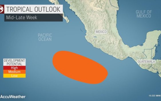
Following closely behind, a second feature could develop during the second half of the week. The expected track of this tropical wave would take it closer to Mexico’s Pacific coast.
Another tropical feature worth monitoring in the central Pacific Ocean is slowly tracking westward early this week. At this point in time however, impacts to Hawaii seem unlikely.
“The Atlantic and Pacific Basins are connected in a way when it comes to tropical development. Usually, during the time that the Atlantic Ocean is very active with several storms, the East Pacific will be quieter, and visa versa,” explained AccuWeather Meteorologist Jake Sojda.
Large-scale weather patterns like El Nino, and La Niña are some of the factors that contribute to which basin is active when.
“As the East Pacific looks to turn more active through mid-August, the focus is likely to return to the Atlantic Basin by the end of the month,” said Doll.
After having a stretch of five record-earliest named tropical systems in a row for the Atlantic 2020 season, ending with Isaias, AccuWeather meteorologists are still monitoring a few tropical waves in the Atlantic Ocean for potential development through mid-August.