- Seven months after Hurricane Helene, Chimney Rock rebuilds with resilience
- Wildfire in New Jersey Pine Barrens expected to grow before it’s contained, officials say
- Storm damage forces recovery efforts in Lancaster, Chester counties
- Evacuation orders lifted as fast-moving New Jersey wildfire burns
- Heartbreak for NC resident as wildfire reduces lifetime home to ashes
Tropical Storm Josephine becomes earliest J-named storm in history
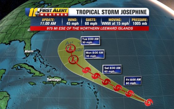
RALEIGH (WTVD) — Tropical Storm Josephine is officially the earliest J-named storm in history.
Josephine formed Thursday morning just under 1,000 miles east-southeast of the northern Leeward Islands. The storm has sustained winds of 45 miles per hour and is moving west-northwest at 15 miles per hour, according to the National Hurricane Center.
Still, Josephine is not expected to be a problem for North Carolina, or any of the continental United States.
The storm’s projected path has it traveling north of the Leeward Islands and Puerto Rico. Models then turn the system even more north, keeping it out to sea before it dies out as an area of low pressure system around Tuesday.
Before Josephine, the previous record for the earliest J-named storm to form was Jose, back on Aug. 22, 2005.
Storm Ready 2020: Preparing in a Pandemic
Last week, Hurricane Isaias made landfall in southeastern North Carolina Monday night and deteriorated to a tropical storm. It triggered a string of tornadoes on the east coast, one of which killed two people in Bertie County.
Last week, National Oceanic Atmospheric Administration updated its 2020 hurricane season outlook to “extremely active.” In May, the NOAA called for an “above normal” hurricane season.
Copyright © 2020 WTVD-TV. All Rights Reserved.