- Houston Cougars take on A&M Aggies in charity exhibition game supporting Hurricane Beryl relief
- Hurricane Helene donations delivered to Avery County for Share the Warmth campaign
- Old Crow Medicine Show founder talks music, hurricane relief and this weekend's big benefit show
- IV fluid shortage caused by hurricane to last for months
- 'It financially annihilated us': Pregnant mother displaced for 2nd time after western NC floods
Forecast: Heavy rain tonight could cause flooding
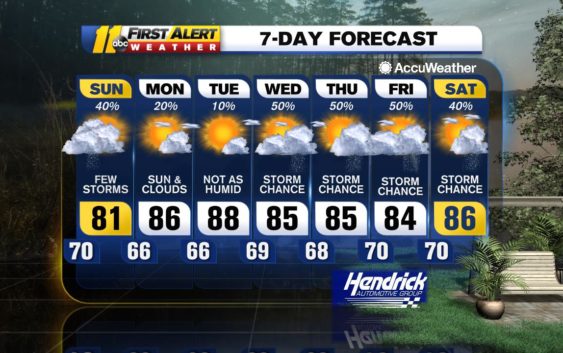
RALEIGH, N.C. (WTVD) — Low pressure over upstate South Carolina tracking to the east-northeast will cross the Triangle tonight causing showers and thunderstorms and the juicy air in place will lead to some locations receiving flooding downpours.
Low pressure will move away to the northeast tomorrow causing clouds and a lingering shower and it will be quite cool for this time of year with clouds breaking later in the afternoon. Drier air will move in from the northwest tomorrow night with patchy clouds and there will be areas of fog that develop overnight and linger into early Monday morning.
Otherwise on Monday, a weak cool front and upper trough will approach from the northwest and it will get milder with clouds and sun and there can be an afternoon shower or thunderstorm in parts of the area, but much of the time will be rain-free.
The front will reach the Appalachians on Tuesday and then cross the Triangle on Wednesday. It will be warmer on Tuesday with sunshine and building clouds and a possible afternoon shower or thunderstorm, then expect more in the way of clouds and more humid conditions with more numerous showers and thunderstorms on Wednesday.
The weather pattern will get stuck again later next week as the front stalls nearby and a slow moving upper level trough of low pressure crosses the Tennessee Valley into the Appalachians. Clouds will win out over sun both Thursday and Friday and there will be mainly afternoon and evening showers and thunderstorms around.
Be Well & Stay Safe!
Robert Johnson
Copyright © 2020 WTVD-TV. All Rights Reserved.