- North Carolina legislators fleshing out details on $500M in additional Hurricane Helene relief
- Dangerous travel conditions: Ice, snow and flooding possible
- How photos lost in disasters like Hurricane Helene find their way home, with a little help from people who care
- Dangerous travel conditions, ice/snow and flooding possible in the mountains Tuesday and Wednesday
- Weather Impact Alert: Dangerous travel conditions, ice/snow and flooding possible in the mountains Tuesday and Wednesday
Double trouble: Two tropical storms trek toward Gulf of Mexico
Two tropical storms are brewing in the Atlantic Ocean right now — Tropical Storm Laura and Tropical Storm Marco.
Tropical Storm Laura will bring heavy rain into Puerto Rico and the Leeward Islands in the Caribbean Sea that could prompt flash flooding and mudslides. One model — which is an outlier — has the tropical storm strengthen to a Category 4 Hurricane.
Saturday morning, Tropical Storm Laura was 110 miles from San Juan, Puerto Rico, moving at 21 mph.
Other models have Tropical Storm Laura strengthen to a Category 1 storm. Even though there is still a lot of uncertainty with the storm, we expect it to strengthen on Tuesday over the Gulf of Mexico before making landfall.
Tropical Storm Laura is forecast to impact the United States, possibly as a hurricane, sometime next week.
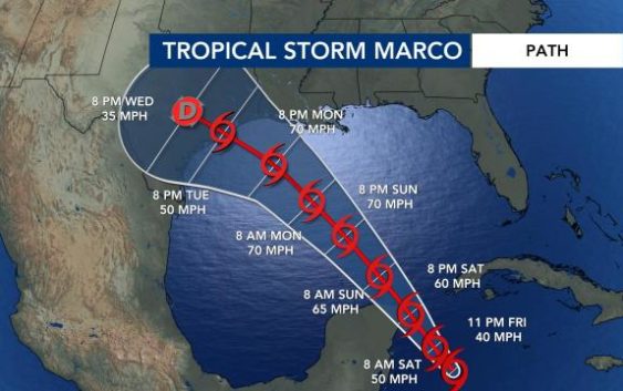
Tropical Storm Marco, which formed Friday night, is expected to strength over the Caribbean throughout Saturday and inch closer to the Yucatan Peninsula of Mexico. This storm is expected to impact areas like Cuba and then could make landfall as a hurricane somewhere in the Gulf of Mexico region of the United States, between Texas and Louisiana, sometime next week.
This year’s Atlantic hurricane season has been busy, with record-setting storms. Marco is the earliest named tropical storm in recorded history, according to WRAL meteorologist Mike Maze. If all the names on the list of 2020 storm names are used before hurricane season ends, meteorologists will use Greek letters to refer to the storms.
The two storms could create a unique situation in the Gulf of Mexico. When tropical systems get within 800 miles of each other, that is a phenomenon called the Fujiwara Effect.
")
“In this case … they would be about 400 miles apart and potentially as much as a day apart, but you can still see how close those centers are together,” meteorologist Elizabeth Gardner said on Friday.
If the storms remain at about equal strength, they would rotate around each other, she explained.
“But if, for some reason, Laura strengthens and we get potentially Marcos being stronger, then Marcos could absorb Laura and it could make a stronger storm,” she said.
Tropical Storm Laura could eventually bring North Carolina rain sometime next week, but the timeline is not exactly clear yet.
“There’s certainly the possibility we could have one storm making landfall on Tuesday morning and another making landfall around Wednesday morning along the Gulf Coast in very close proximity,” said Gardner. “That’s something I can never remember happening.”
A third system near Africa will continue to move over the eastern Atlantic this week. There is a 20% chance of development within the next five days as it continues to move westward,
“I feel sure that it’s probably going to develop, and this time of year you never know how many more are following right behind it,” said Gardner.
Peak hurricane season runs from mid-August to late October, and hurricane season officially ends on Nov. 30. WRAL meteorologist Elizabeth Gardner said very warm ocean temperatures are contributing to the active hurricane season.
