- Dangerous travel conditions: Ice, snow and flooding possible
- How photos lost in disasters like Hurricane Helene find their way home, with a little help from people who care
- Dangerous travel conditions, ice/snow and flooding possible in the mountains Tuesday and Wednesday
- Weather Impact Alert: Dangerous travel conditions, ice/snow and flooding possible in the mountains Tuesday and Wednesday
- North Carolinians perplexed by unexpected DMV refunds tied to Hurricane Helene relief
Triangle under Level 1 risk for severe weather, much less humid
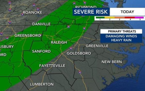
There is a Level 1 risk for severe weather Monday from the Triangle westward.
According to WRAL meteorologist Aimee Wilmoth, storms are most likely between 3 and 5 p.m. Some storms could be strong to severe, with heavy rain and winds at times.
The good news is that the humidity will drop significantly.
On Monday and for much of the week, highs will be in the mid to upper 80s, but it will be less humid, so the air will feel more cool and refreshing. Each morning, expect to be waking up to temperatures in the mid-60s.

“A cold front will be pushing across the state today and that will really decrease dew point temperatures,” said WRAL meteorologist Zach Maloch. “That is something you should notice right when you step outdoors.”
Dense fog is possible Monday morning but should clear around 8 a.m. Scattered thunderstorms and showers will be possible across the viewing area after 2 p.m., but severe weather is not expected.
Tuesday will be one of the warmest days of the week, with a high of 88 degrees, but there is a lesser chance for storms. Starting Wednesday, highs will lean toward the mid 80s, and storm chances return.

Tracking the tropics
Maloch said that Tropical Storms Kyle and Josephine have dissipated, but meteorologists are watching two new disturbances in the Atlantic.
The first wave, currently east of the Windward Islands, will move quickly into the central Caribbean by the middle of the week and has a 50% chance to develop in the next five days.
The second wave is off the coast of Africa. A tropical depression will likely form by the middle and end of the week as it moves westward. This system has a 60% chance for development in the next five days.