- Seven months after Hurricane Helene, Chimney Rock rebuilds with resilience
- Wildfire in New Jersey Pine Barrens expected to grow before it’s contained, officials say
- Storm damage forces recovery efforts in Lancaster, Chester counties
- Evacuation orders lifted as fast-moving New Jersey wildfire burns
- Heartbreak for NC resident as wildfire reduces lifetime home to ashes
2 Hurricanes Could Form In Gulf Of Mexico Next Week — An Apparent First

Tropical Storm Laura could become a hurricane early next week — around the same time another storm develops into a hurricane in the Gulf of Mexico. The system is forecast to bring rain and flooding to Caribbean islands on its way to the U.S. mainland.
Two tropical systems are heading toward the Gulf of Mexico, and both of them could become hurricanes before they near the U.S. mainland early next week, according to the National Hurricane Center.
One storm is currently forecast to hit near the Texas-Louisiana border; the other could reach the Florida Panhandle. Both systems are predicted to strengthen into hurricanes in the Gulf of Mexico, possibly by Monday or Tuesday.
“If that were to occur, it would be first time on record that the Gulf of Mexico has had 2 hurricanes at the same time,” meteorologist Philip Klotzbach says via Twitter.
“There are only a few times in recorded history where two tropical cyclones have shared the Gulf of Mexico,” according to the Weather Prediction Center. “Flash (wayyy) back to 1933 to find a similar example,” it added, referring to a time when a hurricane and a tropical storm coincided in the Gulf.
The two developing systems are currently hundreds of miles apart, but their paths are expected to parallel each other in the Gulf and even partially overlap. Their landfalls will likely be divided by hours, not days. But it’s not yet certain whether both will hit the shore as hurricanes, or whether their paths might diverge.
Tropical Storm Laura, which strengthened into a named storm Friday morning, is in the Atlantic Ocean near the Lesser Antilles. Tropical Depression 14 is in the western Caribbean Sea, off the coast of Honduras.
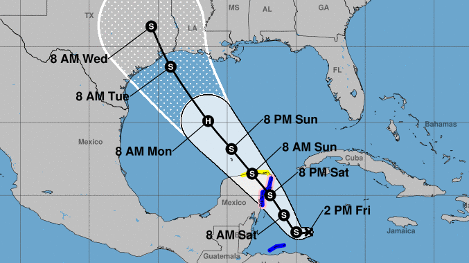
 Tropical Depression 14, which could become Tropical Storm Marcos, is predicted to become a hurricane in the Gulf and then to weaken before hitting the Texas coast near Houston, possibly by Tuesday morning.
Tropical Depression 14, which will become Tropical Storm Marcos if it develops as forecasters expect, will likely arrive first. It’s predicted to become a hurricane in the Gulf, but the National Hurricane Center says it could weaken a bit before hitting the Texas coast near Houston, possibly by Tuesday morning. The system has already triggered a hurricane watch for Cancun and other parts of Mexico’s southeastern coast.
Tropical Storm Laura is causing alerts in Puerto Rico, the Virgin Islands and Hispaniola, where it will drop heavy rain on its way toward Cuba and the Gulf.
“This rainfall could cause flash and urban flooding,” the hurricane center says.
Laura is expected to be a hurricane when it reaches the U.S. coast near the Alabama-Florida border, the center says.
The 2020 Atlantic hurricane season is already setting records with named storms forming at a pace never seen before. The latest estimates from the National Oceanic and Atmospheric Administration call for nearly twice the normal number of named storms in 2020.
Climate change has been linked to the more frequent occurrence of major hurricanes globally as well as the rising number of hurricanes in the Atlantic. In addition to strong winds, many of the most dangerous storms in recent years have brought tremendous amounts of rain – creating new threats to people and infrastructure far inland from the coast.
Subscribe to Today in Houston
Fill out the form below to subscribe our new daily editorial newsletter from the HPM Newsroom.