- Fake job seekers are flooding the market, thanks to AI
- One set of evacuation orders lifted in Caldwell County after wildfire contained
- 'We gutted every building' | Chimney Rock rebuilding after Hurricane Helene
- 'We gutted every building' | Chimney Rock rebuilding after Hurricane Helene
- Debris from Hurricane Helene provides fuel, complicates containment for spring wildfires
Hurricane Marco now tracking toward Gulf Coast; Tropical Storm Laura projected to make landfall on Louisiana coast as Category 2 hurricane
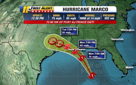
RALEIGH (WTVD) — Marco is now officially a Category 1 hurricane with maximum sustained winds of 75 mph before it is expected to make landfall in southeast Louisiana. Tropical Storm Laura is expected to strengthen to hurricane status before it also hits the same area.
If forecasts are correct, we could see something that has never happened before: two hurricanes in the Gulf of Mexico at the same time. We have seen two systems in the gulf before. There were two tropical storms in the Gulf of Mexico back in 1959, one named Beulah and the other an unnamed storm. And in 1933, a Hurricane and Tropical Storm both hit the U.S.
Fujiwhara effect: Can 2 hurricanes merge into a megastorm?
Hurricane Marco is moving north-northwest through the Gulf of Mexico at 14 miles per hour.
Marco is expected to make landfall on the Louisiana coast as a Category 1 hurricane late Monday into early Tuesday.
Tropical Depression Thirteen officially strengthened into Tropical Storm Laura around 9 a.m. Friday.
Tropical Storm Laura is currently still farther east and over Hispaniola. Some land interaction could weaken it but Laura is now expected to make landfall as a Category 2 hurricane close to the same area previously hit by Marco
Laura now has maximum sustained winds at 45 miles per hour with gusts up to 60 mph and is moving west-northwest at 18 mph.
Storm Ready 2020: Preparing in a Pandemic
KEY POINTS:
- Marco will make landfall Tuesday and Laura will make landfall Wednesday.
- This could be the first time we have two hurricanes in the Gulf.
- There will be no direct impacts to North Carolina.
Copyright © 2020 WTVD-TV. All Rights Reserved.