- Fake job seekers are flooding the market, thanks to AI
- One set of evacuation orders lifted in Caldwell County after wildfire contained
- 'We gutted every building' | Chimney Rock rebuilding after Hurricane Helene
- 'We gutted every building' | Chimney Rock rebuilding after Hurricane Helene
- Debris from Hurricane Helene provides fuel, complicates containment for spring wildfires
Marco Swirls Closer To Gulf Coast Region Bracing For Historic Double Strike
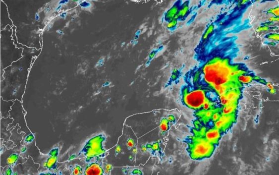
Tropical Storm Marco entered the Gulf of Mexico Saturday evening, and every coastal communitiy from Sabine Pass in Texas to Mobile Bay in Alabama watched and waited to see what came next. Forecasters warned that Marco could grow into a hurricane and possibly make landfall in Louisiana on Monday afternoon.
It could then weaken into a tropical storm and move into East Texas on Tuesday.
In the Caribbean, Tropical Storm Laura lashed Puerto Rico, Hispaniola and Cuba, and it too could grow into a hurricane that could threaten Louisiana by Wednesday, only days after Marco’s arrival.
The bizarre, dramatic possibility of two hurricanes striking the same stretch of coastline sparked memes, black humor and wry comments about 2020 on social media on Friday and Saturday.
But forecasters emphasized that their storm tracks were only educated guesses, at best. “Do not focus of the exact forecast track as average forecast errors are quite large this far out,” read one tweet from the National Weather Service (NWS) Austin/San Antonio office.
“Still a great deal of uncertainty with the path and strength,” another advisory stressed.
No major changes to the tracks for #Marco & #Laura at 10 PM. NHC notes higher than usual uncertainty on intensity of Marco as it battles wind shear, but still forecast to be near hurricane intensity as it reaches the coast. Laura forecast as high end Cat. 1 at landfall. #LAwx pic.twitter.com/UjEunE0Mhi
— Steve Caparotta, Ph.D. (@SteveWAFB) August 23, 2020
By late Saturday evening, the National Hurricane Center (NHC) reported Marco was about 75 miles west of Cuba and moving north-northwest at 13 mph. The Air Force Reserve Hurricane Hunter aircraft dispatched to evaluate it measured sustained winds of 65 mph.
“Strengthening is forecast during the next day or two, and Marco is expected to become a hurricane tonight or on Sunday,” forecasters explained. “Marco is likely to still be at or near hurricane strength when it reaches the northern Gulf coast on Monday. Weakening is forecast to occur while the center moves farther inland Monday night and Tuesday.”
If the tropical storm’s sustained winds exceed 74 mph, it will be classified as a Category 1 hurricane.
“A Storm Surge Watch has been issued from Sabine Pass eastward to the Alabama/Florida border, including Lake Pontchartrain, Lake Maurepas, Lake Borgne, and Mobile Bay,” the NHC advisory reported. “A Hurricane Watch has been issued from Intracoastal City Louisiana eastward to the Mississippi/Alabama border, including Lake Pontchartrain, Lake Maurepas, and Metropolitan New Orleans.”
1-minute Mesoscale Domain Sector #GOES16/#GOESeast Infrared + #GLM Flash Extent Density images showed a few convective bursts (to -85ºC) near the center of TS #Marco over the past 8 hours, with 2 bursts of #lightning activity (most notably around 03 UTC): https://t.co/BWuQBM6qPQ pic.twitter.com/WIMaYfElYF
— Scott Bachmeier (@CIMSS_Satellite) August 23, 2020
If Marco grew into a hurricane, it would be the third hurricane of the 2020 hurricane season.
NPR reported Louisiana Gov. John Bel Edwards appreciated the unique danger his state may face in the coming days. “This is the very first time in history that we’ve had two storms forecasted to hit at the same time in the Gulf Coast,” he said.
Crews on oil and gas rigs in the Gulf have been evacuated, NPR added. Also, Alabama’s governor explained elections set for Tuesday may have to be delayed because of the storms. Mississippi’s governor has issued a state of emergency.
Houston Public Media reported that Galveston County officials were not planning major evacuations, and ferry service would continue. County Judge Mark Henry said state officials had promised 100 buses for Galveston County, HPM reported, which would help any evacuation operation observe necessary COVID-19 social distancing requirements in the buses.
In Corpus Christi, memories of Hurricane Hanna resonated. Earlier on Saturday, when a previous track showed Marco targeting the central Texas coast, city workers filled 6,000 sandbags on Saturday for residents of low lying areas. Those and other preparatory efforts took place as piles of debris from Hanna still sat on curbs waiting for pickup.
Throughout Saturday, Tropical Storm Laura tormented Puerto Rico and Hispaniola with severe winds and rain. By late Saturday evening, it was about 25 miles southeast of Santo Domingo, Dominican Republic. It moved west-northwest at 16 mph. Sustained winds were measured at 50 mph.
“No significant changes in strength are forecast during the next 36 to 48 hours while Laura moves near or over Hispaniola and Cuba,” forecasters explained. “Strengthening is forecast once Laura moves into the Gulf of Mexico Monday night and Tuesday.”
As with Marco, if Laura’s sustained winds exceed 74 mph, it will be classified as a Category 1 hurricane. Forecasters roughly estimated landfall somewhere in Louisiana sometime on Wednesday.
FYI #houwx #glswx #txwx pic.twitter.com/aS7T7wBcvS
— NWS Houston (@NWSHouston) August 21, 2020
The emergence of both storms initially sparked curiosity in some observers, especially at first when it appeared both storms might make landfall simultaneously. But that scenario grew increasingly unlikely given the current progress of both storms, with Marco likely to make landfall first. Nevertheless, some people wondered what might’ve happened if the storms moved closer to each other … or perhaps combined to become a larger storm.
The horror movie idea was not a fantastical one. The National Weather Service (NWS) explained that two storms can theoretically come close enough to affect each other, push each other away or the stronger one could absorb the weaker one. Weather scientists described it as the Fujiwhara Effect, named for Sakuhei Fujiwhara, the director of a weather observatory in Japan who researched it.
“Two storms closer in strength can gravitate towards each other until they reach a common point and merge, or merely spin each other around for a while before shooting off on their own paths,” the NWS added. “In rare occasions, the effect is additive when the hurricanes come together, resulting in one larger storm instead of two smaller ones.”
However, forecasters emphasized that such an occurrence would be extremely rare and that it was still too early to predict anything about the storms beyond their general tracks through Tuesday.
NPR noted that the 2020 Atlantic hurricane season has seen “named storms forming at a pace never seen before.” One weather expert estimated 2020 has seen 30 named storm days by Aug. 22, a record exceeded only by the 1995, 2005 and 2008 storm seasons.
The National Oceanic and Atmospheric Administration recently warned that this year’s season could see twice the normal number of named storms.
The remaining names from 2020’s list of “Tropical Cyclone Names” are Nana, Omar, Paulette, Rene, Sally, Teddy, Vicky, Wilfred. If that list is exhausted, the NHC explained, “additional storms will take names from the Greek alphabet.”
The Atlantic has already generated 31 named storm days in 2020. 10 entire Atlantic #hurricane seasons in the satellite era (since 1966) had <31 named storm days: 1972, 1977, 1982, 1983, 1986, 1991, 1993, 1994, 1997, and 2009. #Laura #Marco pic.twitter.com/sAuwC7tv9N
— Philip Klotzbach (@philklotzbach) August 23, 2020
The latest set of storms developed just as the National Oceanic and Atmospheric Administration (NOAA) explained how its modern fleets of satellites have improved hurricane forecasting.
The Joint Polar Satellite System views the entire Earth both during the day and the night, and it measures sea and air conditions to help predict a hurricane’s path. Geostationary Operational Environmental Satellites (GOES) constantly watch the Western Hemisphere for hurricane development. They send back information on hurricane wind speeds and lightning activity, which reveal their intensity.
NOAA hurricane researcher Jason Dunion said they can predict paths and see into hurricanes better than ever before. “These different satellite platforms are giving us about twice the image resolution that we used to get,” he explained. “Think about going from a low definition TV to an HDTV.”
Dunion said forecasting offices can quickly interpret the data. “We’re actually taking that data and delivering it to the forecast centers and to the modeling centers,” he said, “so the models are ingesting all of this satellite information to really improve the forecasts and protect lives and property. That’s really what it’s all about.”
TPR was founded by and is supported by our community. If you value our commitment to the highest standards of responsible journalism and are able to do so, please consider making your gift of support today.