- Here’s how Austin-area leaders are preparing for wildfire threats this summer
- Harris County sues Trump administration, cites threat to hurricane season preparedness
- Prescribed burn in Morrow Mountain aims to prevent future wildfires
- Prescribed burns aim to prevent wildfires in Stanly County
- Prepare for hurricane season with the Town of Leland Hurricane Expo
Tropical Storm Laura shift slightly west, while Marco takes aim at Louisiana
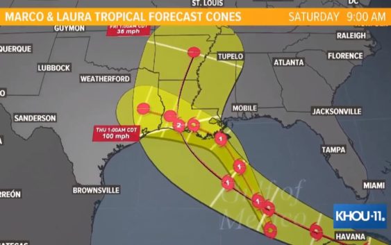
Both storms are expected to be in the Gulf of Mexico together early next week.
HOUSTON — Tropical Storm Marco made a major shift Saturday afternoon, with the National Hurricane Center moving the center of the forecast cone all the way from the Houston-Galveston area to New Orleans.
Southeast Texas is still not out of the woods, as this storm has been unpredictable and the models are still scattered. But the shift is good news for our area.
Marco moved into the Gulf of Mexico Saturday evening just before 7 p.m. There are storm surge and hurricane watches in effect for portions of the northern Gulf coast.
Marco is one of two systems we’re keeping an eye on as we reach the peak of hurricane season.
The other system is Tropical Storm Laura out in the Atlantic. Below is what you need to know about both storms.
Tropical Storm Marco shifts far to the east
The center of the forecast cone for Tropical Storm Marco now takes the storm to the eastern Louisiana coast, with a projected landfall Monday as a Category 1 hurricane.
Right now, Marco is 185 miles northwest of the western tip of Cuba. It has maximum sustained winds of 70 miles per hour and is moving to the north-northwest at 13 miles per hour.
A hurricane warning has been issued for the coast of Louisiana from Morgan City to the Mouth of the Pearl River.
A tropical storm warning has been issued for Louisiana for Lake Pontchartrain, Lake Maurepas, and Metropolitan New Orleans
Tropical Storm Laura also shifts to the east
If Tropical Storm Laura and Tropical Storm Marco stay on their current paths, it could be a nasty one-two punch for Louisiana.
Laura is projected to make landfall in Louisiana as a Category 1 storm on Wednesday, two days after Marco.
Right now, Laura is 95 miles southeast of Port-au-Prince, Haiti. It has maximum sustained winds of 45 miles per hour and is moving to the west-northwest at 18 miles per hour.
Laura is also expected to become a hurricane early next week.
There’s still a lot of uncertainty in the track and intensity
Intensity if the least predictable factor of tropical weather and Laura could be significantly stronger, even possibly a major hurricane in the Gulf of Mexico by early next week.
What to expect from Marco
One of the biggest dangers with tropical weather is storm surge. Storm surge along the northern Gulf coast could range from 2-4 feet through most of Louisiana to 3-5 feet near New Orleans east to Mississippi and parts of Alabama
Tropical-storm-force winds could start as early as Sunday in the watch areas along the northern Gulf Coast. but are mostly likely to start before sunrise Monday.
Heavy rainfall with 1 to 3 inches is expected along the north-central Gulf Coast and isolated totals of 5 inches are possible, possibly resulting in flash and urban flooding.
What is the Fujiwhara Effect and could these two storms merge?
In a year that’s seen everything from a global pandemic to murder hornets, now we have a possibility of not one but two hurricanes in Gulf waters at the same time. Tropical Depression 13 was the first to become a named storm as Laura on Friday morning. Tropical Depression 14 became Tropical Storm Marco Friday night. Could they merge in the Gulf? It’s possible. But not likely. Here’s what to know about the Fujiwhara Effect.
Be prepared this hurricane season
It’s way too early to know the exact intensity and track these two systems will take. Regardless, we’re in a very active hurricane season, so it’s a good idea to know what you’ll need if a storm was approaching.
Here is a list of important items you should have at home or take with you if you evacuate:
- Water – at least 1 gallon daily per person for 3-7 days; also fill bathtub and other containers; Gator Aid is good to fend off dehydration
- Food – at least enough for 3-7 days; non-perishable packaged or canned food; juices; foods for infants or elderly family members; snack foods; food for special diets
- Non-electric can opener
- Cooking tools, fuel
- Paper plates and cups, plastic utensils
- Bedding: Blankets, Pillows, etc.
- Clothing
- Rain gear
- Sturdy shoes
- First Aid Kit, Medicines, Prescription Drugs
- Toilet paper, paper towels, trash bags
- Toiletries, hand sanitizer, hygiene items, moisture wipes, dry shampoo
- Flashlight, batteries, lantern
- Radio: Battery operated and NOAA weather radio
- Telephones: Fully charged cell phone with extra battery; chargers; traditional (not cordless) telephone set
- Cash (with some small bills) and Credit Cards: Banks and ATMs may not be available for extended periods
- Important documents: Place in a waterproof container or watertight resealable plastic bag: Should include insurance, medical records, bank account numbers, Social Security card, prescriptions, etc.
- Tools: Keep a set with you during the storm
- Gas: Fill up your vehicles several days before landfall is expected; Gas stations could lose power during a storm and supply trucks may not be able to reach the area
- Pet care items: Proper identification, immunization records, medications, ample supply of food and water; a carrier or cage; muzzle and/ or leash
- Bleach without lemon or any other additives
- Fire extinguisher
- Mosquito repellent
- Keys
- Toys, books and games for children
- Duct tape
- Cell Phone charging stations – locations where you can charge mobile devices