Storm Updates: Marco Fizzles As It Nears Gulf Coast; Laura Still To Become Hurricane

Tropical Storm Laura is on the cusp of becoming a hurricane as it nears the Gulf of Mexico, but Tropical Storm Marco is weakening as it approaches Louisiana, easing coastal communities’ worst fears of a potential one-two punch by powerful hurricanes.
The storms had been seen as a rare chance for two hurricanes to possibly occupy the Gulf of Mexico at the same time. That won’t happen – but while Laura and Marco don’t have fearsome winds, they promise to bring a perilous amount of water to low-lying towns and communities along the Gulf Coast.
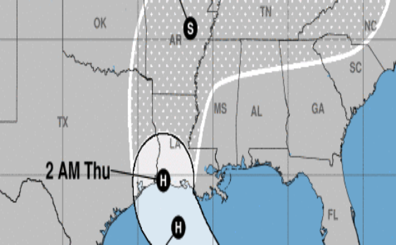
Laura’s forecast track calls for the storm to make landfall as a hurricane near the Texas-Louisiana border late Wednesday or early Thursday — a prediction that has shifted to the west in recent days, after early forecasts called for landfall near the Florida Panhandle.
The new track has Laura drenching some of the same parts of Louisiana that Marco will douse in the early part of the week.
Because one storm will follow closely on the other’s heels, Louisiana Gov. John Bel Edwards says residents should prepare to ride out the tropical weather. Another complicating factor: Louisiana is already coping with a COVID-19 outbreak, reducing capacity for shelters and evacuation efforts.
“The first 72 hours is on you,” Edwards told residents on Sunday. “That is because the second storm comes in so close that there may not be much of a window when we can fly search-and-rescue helicopters, when we can get out with high-water vehicles and those sorts of things.”
Tropical Storm Laura is currently just south of Cuba, in the Caribbean Sea. “Gradual strengthening is expected, and Laura is forecast to become a hurricane by early Tuesday,” the National Hurricane Center says.
By late this week, “Laura is expected to produce rainfall of 5 to 10 inches, with isolated maximum amounts of 15 inches across portions of the west-central U.S. Gulf Coast near the Texas and Louisiana border” and inland areas, the hurricane center says.
Laura’s worst impact in the U.S. will be seen from late Wednesday into Friday. Federal forecasters say its intense rainfall could spark “widespread flash and urban flooding” and possibly cause some streams and rivers to flood.
Laura has triggered tropical storm warnings in parts of the Cayman Islands and Cuba, as well as in the Florida Keys from Craig Key to Key West — and farther west, out to Dry Tortugas National Park.
Hurricane Marco weakened back into a tropical storm Sunday night, prompting forecasters to lift a hurricane watch for New Orleans and nearby areas. But the system is still bringing heavy rain and gusty winds to parts of the northern Gulf Coast on Monday, and it could saturate the ground in some of the same areas Laura will hit later this week.
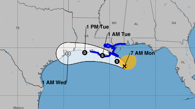
Marco’s maximum sustained winds have lessened to 50 mph. The storm is about 85 miles south-southeast of the Mississippi River’s mouth, the hurricane center said in its 8 a.m. ET update. It’s moving northwest at 10 mph, and is expected to skim along Louisiana’s coast before dissipating.
“Marco is forecast to approach the coast of Louisiana this afternoon, and then turn westward and move very close to the coast of Louisiana through Tuesday night,” the NHC says.
While the worst fears of Marco’s impact seem to be allayed, it is bringing a dangerous amount of water to the Gulf Coast. A storm surge warning is in effect from Morgan City, La., to Ocean Springs Miss., and Lake Borgne, east of New Orleans. In that area, the surge and/or coastal flooding could range from 2 to 4 feet.
“This is a life-threatening situation,” the hurricane center says, adding that any people in the warning area “should take all necessary actions to protect life and property from rising water and the potential for other dangerous conditions.”
Flood Hazard Outlook map for #lawx #arwx #txwx
Remember #TurnAroundDontDrown if you see flooded roads! pic.twitter.com/eoOWWUsrEE— NWS Shreveport (@NWSShreveport) August 24, 2020
A tropical storm warning for Marco is also in effect from Intracoastal City, La., to the Mississippi/Alabama border.
Climate change has been linked to the more frequent occurrence of major hurricanes globally as well as the rising number of hurricanes in the Atlantic. In addition to strong winds, many of the most dangerous storms in recent years have brought tremendous amounts of rain – creating new threats to people and infrastructure far inland.
9(MDAxODM1MzQyMDEyMTY4OTc2NzRhNzJmYw004))
