- Fake job seekers are flooding the market, thanks to AI
- One set of evacuation orders lifted in Caldwell County after wildfire contained
- 'We gutted every building' | Chimney Rock rebuilding after Hurricane Helene
- 'We gutted every building' | Chimney Rock rebuilding after Hurricane Helene
- Debris from Hurricane Helene provides fuel, complicates containment for spring wildfires
Tropical Storm Laura edges closer to Gulf of Mexico; Marco continues to fizzle

All eyes are on Tropical Storm Laura, which is expected to strengthen into a hurricane in the Gulf of Mexico and affect the Gulf coast.
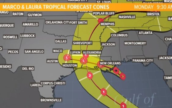
People in Houston and all along the Gulf coast are keeping a very close eye on Tropical Storm Laura. The National Hurricane Center‘s latest track has it making landfall as a Category 2 hurricane sometime Wednesday into Thursday along the western Louisiana coast. But the forecast cone goes from the Houston area’s eastern counties all the way to near New Orleans.
While the tropical storm and surge warnings for Tropical Storm Marco have been discontinued, the NHC says they’ll likely issue new watches and/or warnings for portions of the U.S. Gulf coast for Laura.
Since parts of the Houston area are in the forecast cone for Tropical Storm Laura, so we’ll need to watch it closely. There is still a lot of uncertainty with the storm.
The storm isn’t expected to stall over Houston. If anything, this would be a big wind and storm surge event for the Houston area if it shifts our way.
As of the 1 p.m. update Monday, Laura was 15 miles south of Cayo Largo. It had maximum sustained winds of 60 miles per hour and gusts up to 70 miles per hour. It was moving to the west-northwest at 20 miles per hour.
RELATED: ‘People not taking this seriously’: Galveston County judge warns storm surge could force evacuations
It could trigger evacuations and have significant storm surge for Galveston and Bolivar.
Heavy rainfall is likely across Cuba and Jamaica today, causing life-threatening flash flooding and mudslides. Tropical storm conditions are expected in the Dry Tortugas and in the lower Florida Keys later today.
The long-range track remains uncertain. Intensity is the least predictable factor of tropical weather and Laura could be significantly stronger, even possibly a major hurricane in the Gulf of Mexico by early this week.
Marco weakens to tropical storm as it edges closer to Louisiana
Marco weakened to a tropical storm Sunday night as it faced wind shear and dry air in the central-northern Gulf of Mexico. Winds decreased to 70 mph, and it is forecast to stay a tropical storm as it skirts the Louisiana coastline on Monday. The threat for the Houston area has diminished.
Gov. Abbott declares state of disaster for 23 Texas counties
With the threat of Laura, Gov. Greg Abbott on Sunday declared a state disaster to assist Texans who could be affected by the storms. Abbott announced Monday morning that FEMA had approved the declaration.
The state disaster declaration was issued for 23 counties, including all coastal surge counties, plus Bexar County, which will be for staging and sheltering.
The following counties are included in the disaster declaration: Aransas, Bexar, Brazoria, Calhoun, Cameron, Chambers, Galveston, Hardin, Harris, Jackson, Jasper, Jefferson, Kenedy, Kleberg, Liberty, Matagorda, Newton, Nueces, Orange, Refugio, San Patricio, Victoria, and Willacy
Make sure you’re prepared for a hurricane
It’s way too early to know the exact intensity and track of Laura, but the one thing you can count on — you’ll be better off if you’re prepared.
Here is a list of important items you should have at home or take with you if you evacuate:
- Water – at least 1 gallon daily per person for 3-7 days; also fill bathtub and other containers; Gator Aid is good to fend off dehydration
- Food – at least enough for 3-7 days; non-perishable packaged or canned food; juices; foods for infants or elderly family members; snack foods; food for special diets
- Non-electric can opener
- Cooking tools, fuel
- Paper plates and cups, plastic utensils
- Bedding: Blankets, Pillows, etc.
- Clothing
- Rain gear
- Sturdy shoes
- First Aid Kit, Medicines, Prescription Drugs
- Toilet paper, paper towels, trash bags
- Toiletries, hand sanitizer, hygiene items, moisture wipes, dry shampoo
- Flashlight, batteries, lantern
- Radio: Battery operated and NOAA weather radio
- Telephones: Fully charged cell phone with extra battery; chargers; traditional (not cordless) telephone set
- Cash (with some small bills) and Credit Cards: Banks and ATMs may not be available for extended periods
- Important documents: Place in a waterproof container or watertight resealable plastic bag: Should include insurance, medical records, bank account numbers, Social Security card, prescriptions, etc.
- Tools: Keep a set with you during the storm
- Gas: Fill up your vehicles several days before landfall is expected; Gas stations could lose power during a storm and supply trucks may not be able to reach the area
- Pet care items: Proper identification, immunization records, medications, ample supply of food and water; a carrier or cage; muzzle and/ or leash
- Bleach without lemon or any other additives
- Fire extinguisher
- Mosquito repellent
- Keys
- Toys, books and games for children
- Duct tape
- Cell Phone charging stations – locations where you can charge mobile devices