- Fake job seekers are flooding the market, thanks to AI
- One set of evacuation orders lifted in Caldwell County after wildfire contained
- 'We gutted every building' | Chimney Rock rebuilding after Hurricane Helene
- 'We gutted every building' | Chimney Rock rebuilding after Hurricane Helene
- Debris from Hurricane Helene provides fuel, complicates containment for spring wildfires
Only remnants left of Marco, but Laura expected to become hurricane on Tuesday

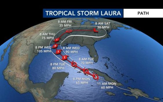
Marco is disappearing but Tropical Storm Laura is expected to develop into a Category 2 storm Tuesday and impact the Gulf Coast.
Marco, which made landfall near the mouth of the Mississippi River on Monday night, is starting to dissipate, according to the 5 a.m. update from the National Hurricane Center. Its remnants will bring gusty winds and scattered storms from Florida to Louisiana through Tuesday, Gardner said, and even North Carolina and South Carolina will see some cloud cover.
Tropical Storm Laura is expected to make landfall along the Louisiana or Texas coast Tuesday evening as a strong Cat. 2 hurricane.
Gardner said it’s possible it could be Cat. 3 when it makes landfall.
Laura will have more severe impacts on the Gulf Coast overnight Wednesday and into Thursday morning.
“Dangerous storm surge, flooding, and hurricane force winds are likely along the Louisiana and Texas coast,” said WRAL Aimee Wilmoth.
Gardner said Laura won’t impact Louisiana like Hurricane Katrina did in 2005, but the effects will be serious. Between 4 to 6 feet of storm surge is possible along Louisiana’s coast, and flash flooding is possible, with 3 to 6 inches of rain falling.
Tuesday evening, Laura had moved off the coast of Cuba and was in warm waters, which would make it favorable for rapid intensification.
“The forecast calls for it to be almost a major hurricane by the time it gets close to making landfall,” said WRAL meteorologist Mike Maze.
According to The Associated Press, officials fear a history-making onslaught of life-threatening winds and flooding along the coast, stretching from Texas to Alabama, as two storms affect the Gulf.
It’s rare for two storms to hit the Gulf in only a matter of days.
Why the storms gain strength over the Gulf
Water temperatures in the Gulf of Mexico are warm, with temperatures in the mid-80s, which will likely cause Laura to strengthen as it gets closer to the U.S.
“Warm sea surface temperatures really help these storms fuel and intensify,” WRAL Peta Sheerwood said.
This year’s Atlantic hurricane season has been busy, with record-setting storms. Tropical Storm Marco was the earliest named M-storm in recorded history, according to WRAL meteorologist Mike Maze.
If all the names on the list of 2020 storm names are used before hurricane season ends, meteorologists will use Greek letters to refer to the storms.
Peak hurricane season runs from mid-August to late October, and hurricane season officially ends on Nov. 30. WRAL meteorologist Elizabeth Gardner said very warm ocean temperatures are contributing to the active hurricane season.


