- One set of evacuation orders lifted in Caldwell County after wildfire contained
- 'We gutted every building' | Chimney Rock rebuilding after Hurricane Helene
- 'We gutted every building' | Chimney Rock rebuilding after Hurricane Helene
- Debris from Hurricane Helene provides fuel, complicates containment for spring wildfires
- David & Nicole Tepper increase Hurricane Helene relief commitment to $750k
Hurricane Laura nearing Category 5 status as sustained winds reach 150 mph

Hurricane Laura is expected to make landfall in southwestern Louisiana as a major hurricane. Accuweather
Hurricane Laura is increasing in strength and growing close to being designated ad a Category 5 hurricane. Currently a Category 4 storm, Laura is described as an “extremely dangerous” storm. The storm is forecast to stay a Category 4 hurricane making landfall along the Texas and Louisiana coasts.
Catastrophic storm surge, extreme winds, and flash flooding are expected along the northwest Gulf Coast tonight.
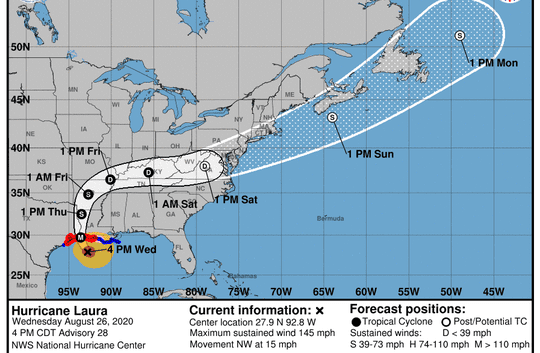
On the forecast track, “Laura will approach the Upper Texas and southwest Louisiana coasts this evening and move inland within that area tonight.
“The center of Laura is forecast to move over northwestern Louisiana tomorrow, across Arkansas Thursday night, and over the mid-Mississippi Valley on Friday,” the National Hurricane Center said.
What we know: Hurricane Laura’s Texas landfall
As of 7 p.m. Wednesday, Laura was recorded by the NOAA as having maximum sustained winds of 150 mph. That’s 8 mph away from becoming a Category 5 hurricane, according to the Saffir-Simpson scale.
It is located 120 miles south-southeast of Port Arthur, Texas, and is moving northwest at 15 mph.
Watches and warnings are in effect for areas across Texas to the mouth of the Mississippi River.
Map the storm: See live spaghetti models, tracker maps as storm nears
Evacuations: Texas cities, counties with evacuation orders as Hurricane Laura looms
Where is Hurricane Laura now?
- Location: 155 miles south-southeast of Port Arthur, Texas
- Movement: Northwest at 15 mph
- Maximum sustained winds: 145 mph
- Next update: 7 p.m.
Information gathered from the National Hurricane Center.
Hurricane Laura watches and warnings
A Storm Surge Warning is in effect for
- Freeport, Texas to the Mouth of the Mississippi River
A Hurricane Warning is in effect for
- San Luis Pass, Texas to Intracoastal City, Louisiana
A Tropical Storm Warning is in effect for
- Sargent, Texas to San Luis Pass
- East of Intracoastal City, Louisiana to the Mouth of the Mississippi River
A Storm Surge Watch is in effect for
- Freeport, Texas to San Luis Pass
A Hurricane Watch is in effect for
- East of Intracoastal City to west of Morgan City, Louisiana
When will Hurricane Laura hit?
(Tip: If the map above doesn’t load, click here.)
Read or Share this story: https://www.caller.com/story/news/2020/08/26/hurricane-laura-category-4-nhc-updates-texas-impacts/3432520001/