- New legislative panels will investigate ‘facts and circumstances’ of deadly Central Texas floods
- Heavy rain floods downtown Whiteville forcing local businesses to deal with damage again
- New legislative panels will investigate “facts and circumstances” of deadly Central Texas floods
- Springfield Middle School fully reopens next week, a year after devastating EF3 tornado
- Dozens rescued as remnants of typhoon hits Alaska while nor’easter brings flooding to East Coast
Hurricane Laura strengthens to major Category 3 hurricane
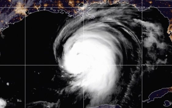
Hurricane Laura is the first major hurricane of 2020 and could be even stronger before making landfall on the Gulf coast in Louisiana or Texas.
CHARLOTTE, N.C. — Hurricane Laura is now a category three hurricane with sustained winds of 115 mph and will continue to strengthen as it moves over the warm waters of the Gulf of Mexico towards the United States.
As of 8 a.m. Wednesday, August 26, Laura has sustained winds of 115 mph with even higher gusts. Laura is currently about 280 miles south-southeast of Lake Charles, Louisiana.
The National Hurricane Center’s latest track for Hurricane Laura has it making landfall, likely as a Category 3 or Category 4 hurricane. The models are coming to an agreement about where it will come ashore, and it looks to be right along the Louisiana-Texas border.
Forecasters at the National Hurricane Center expect Laura to see more rapid intensification with the possibility of becoming a category four hurricane before making landfall. First Warn Chief Meteorologist Brad Panovich said Laura could reach maximum sustained winds of 150 mph.
Laura is expected to bring devastating storm surge and powerful winds to the Louisiana and Texas coastlines when it makes landfall. Some areas, including Galveston, Texas, could see up to 12 feet of storm surge.
So, why is Laura forecast to strengthen? It is moving into a very favorable environment with low wind shear and very warm water.