- Sellers and Rantanen are among the NHL trade deadline winners. Hurricanes and Boeser are some losers
- Hurricane forecasters express concern over NOAA job cuts impact
- FEMA deadline for Hurricane Helene recovery aid extended again
- Tornado drills to take place at schools across North Carolina Friday morning
- Hays County emergency alerts cause confusion during Tuesday's wildfires
Hurricane Laura now a Category 3 storm after landfall, extreme conditions ahead

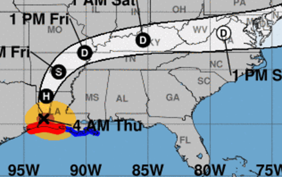
Hurricane Laura downgraded to a Category 3 storm Thursday morning after making landfall near Cameron, Louisiana overnight.
Catastrophic storm surge, extreme winds, and flash flooding continues in portions of Louisiana Thursday morning.
As of 4 a.m., Laura was recorded by the NOAA as having maximum sustained winds of 120 mph. Hurricane-force winds are expected through much of the night in the warning areas, with catastrophic damage expected near where the eyewall moved ashore.
The storm was located about 50 miles northeast of Port Arthur, Texas.
Laura is moving north at 15 mph.
The storm will dump 8-12 inches of rain from far southwest Louisiana and the Golden Triangle of Southeast Texas with isolated totals of 18 inches. About 5-10 inches with isolated totals of 15 inches are expected across central and the rest of western Louisiana into far eastern Texas, according to the national weather service update.
Several tornadoes are expected overnight over Louisiana, far southeast Texas, and southwestern Mississippi. The risk for tornadoes will continue through the day across Louisiana, Arkansas, and western Mississippi.
Rapid weakening is forecast, and Laura is expected to become a tropical storm later today, the National Hurricane Center said.
Laura forecast to be ‘major’ Cat 3: What does this mean?
Map the storm:See live spaghetti models, tracker maps as storm nears
Evacuations: Texas cities, counties wit evacuation orders as Hurricane Laura looms
Where is Hurricane Laura now?
- Location: 30 miles (south-southwest) of Lake Charles, Louisiana
- Movement: North at 15 mph
- Maximum sustained winds: 120 mph
- Next update: 7 a.m.
Information gathered from the National Hurricane Center.
Hurricane Laura watches and warnings
A Storm Surge Warning is in effect for
- Freeport, Texas to the Mouth of the Mississippi River
A Hurricane Warning is in effect for
- High Island, Texas to Intracoastal City, Louisiana
A Tropical Storm Warning is in effect for
- East of Intracoastal City, Louisiana to the Mouth of the
Mississippi River
Read or Share this story: https://www.caller.com/story/news/2020/08/27/hurricane-laura-landfall-track-path-nhc-updates-texas-louisiana/3439752001/