- Sellers and Rantanen are among the NHL trade deadline winners. Hurricanes and Boeser are some losers
- Hurricane forecasters express concern over NOAA job cuts impact
- FEMA deadline for Hurricane Helene recovery aid extended again
- Tornado drills to take place at schools across North Carolina Friday morning
- Hays County emergency alerts cause confusion during Tuesday's wildfires
Hurricane Laura surging north across western La. as Category 3 storm

As of 5 a.m. EST, the National Hurricane Center says Laura has maximum sustained winds of 120 mph with higher gusts, making it a Category 3 storm. Laura is moving north at 15 mph, a brisk pace and good news for keeping rain totals down.
The National Hurricane Center said the storm made landfall near Cameron, Louisiana. It then had maximum sustained winds of 150 mph (240 kph), making it the most powerful hurricane to strike the U.S. so far this year.
The storm’s power has raised fears of a 20-foot (6-meter) storm surge that forecasters say would be “unsurvivable” and capable of sinking entire communities on the Texas and Louisiana coast.
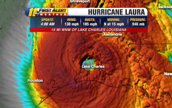
As of 4am, Laura weakening but still a CAT 4 and moving over Lake Charles, LA. Catastrophic storm surge and wind damage expected. Still too dark to see the scope of the damage… pic.twitter.com/C6tHxGVSb0
— Steve Stewart (@StewartABC11) August 27, 2020
BREAKING: Hurricane Laura, which made landfall as a Cat 4 storm, has been downgraded to a Cat 3 with winds of 120 mph. Laura is moving at 15 mph north.
— Julie Wilson (@JulieABC11) August 27, 2020
Hurricane categories: Learn what the numbers mean
Galveston, Texas has already issued a mandatory evacuation, instructing all residents to leave the island Tuesday.
Forecasters warn that seawater higher than a basketball hoop could swamp entire communities.
WATCH: What is the Saffir-Simpson scale for hurricanes
Towns near the Louisiana-Texas state line are bracing for the worst. Laura already killed at least 11 people in the Dominican Republic and Haiti, where it knocked out power and caused flooding in the two nations that share the island of Hispaniola.
Laura would transition to a post-tropical depression and work its way through the Ohio River Valley and could race east to bring North Carolina some rain this weekend. Laura could also carry tropical-storm-force winds into Arkansas
Fujiwhara effect: Can 2 hurricanes merge into a megastorm?
Copyright © 2020 WTVD-TV. All Rights Reserved.