- Fake job seekers are flooding the market, thanks to AI
- One set of evacuation orders lifted in Caldwell County after wildfire contained
- 'We gutted every building' | Chimney Rock rebuilding after Hurricane Helene
- 'We gutted every building' | Chimney Rock rebuilding after Hurricane Helene
- Debris from Hurricane Helene provides fuel, complicates containment for spring wildfires
Remnants of Hurricane Laura bring risk of wind gusts, severe weather, isolated tornadoes
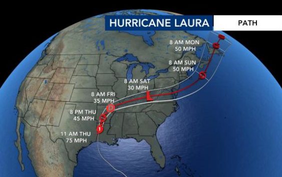
North Carolina will see some rain and severe weather this weekend not directly from Hurricane Laura but from a cold front that the storm’s remnants will strengthen.
The center of the storm’s remnants are expected to pass just north of our state, but the southern section which will cross over parts of NC is expected to have the greatest potential for severe storms.
Impacted sections of NC could expect 30-40 mph wind gusts, heavy rain and isolated tornadoes. Most of western and central North Carolina will be under a Level 2 risk for severe weather Saturday as Laura passes to our north.
What’s left of Laura will be closest to North Carolina on Saturday, according to WRAL meteorologist Kat Campbell, and that’s when a cold front will strengthen and bring possible severe weather to our region midday Saturday through Saturday evening.

WRAL meteorologist Elizabeth Gardner said the heaviest rain may be closer to the Virginia line.
After the cold front passes, the Triangle will experience much milder temperatures, with temperatures in the mid 80s starting Sunday and for the new work week.
