- Demolition begins on flood-damaged homes in Stoney Creek as neighbors await relief
- NC Office of State Fire Marshal aiding in Hurricane Melissa relief efforts
- U.S.-based aid groups rush to get supplies into storm-battered Jamaica after Hurricane Melissa
- Travelers stuck in Jamaica due to Hurricane Mellissa forced to pay for unwanted extended stay
- Raleigh police officer awaits word from family in Jamaica after Hurricane Melissa devastation
Weakening Laura combined with cold front could bring severe weather to NC this weekend
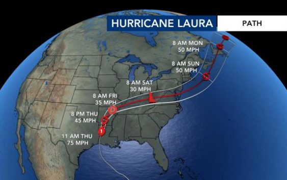
North Carolina will see some rain and severe weather this weekend not directly from Hurricane Laura but from a cold front that the storm’s remnants will strengthen.
WRAL meteorologist Zach Maloch said Laura is expected to weaken to a tropical depression by Friday. It is expected to track to the northeast, bringing heavy rain to Arkansas and Tennessee before getting closer to North Carolina.
What’s left of Laura will be closest to North Carolina on Saturday, Maloch said, and that’s when a cold front will strengthen and bring possible severe weather to our region midday Saturday through Saturday evening.
Most of western and central North Carolina will be under a Level 2 risk for severe weather Saturday as Laura passes to our north, with isolated tornadoes, gusty winds and heavy rain all possible. Flooding should not be a concern.

WRAL meteorologist Elizabeth Gardner said the heaviest rain may be closer to the Virginia line.
After the cold front passes, the Triangle will experience much milder temperatures, with temperatures in the mid 80s starting Sunday and for the new work week.
