- Fake job seekers are flooding the market, thanks to AI
- One set of evacuation orders lifted in Caldwell County after wildfire contained
- 'We gutted every building' | Chimney Rock rebuilding after Hurricane Helene
- 'We gutted every building' | Chimney Rock rebuilding after Hurricane Helene
- Debris from Hurricane Helene provides fuel, complicates containment for spring wildfires
Remnants of Laura could bring severe weather to the Carolinas Saturday
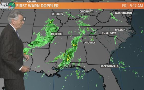
The remnants of Laura could bring severe storms to the area Saturday afternoon. Damaging winds and rain are main concerns.
CHARLOTTE, N.C. — Although the remnants of Laura will be well north of North Carolina and the Charlotte area, there could be some stormy weather Saturday.
Damaging winds and an isolated tornado are the main concerns with stronger thunderstorms that could form late Saturday morning into the afternoon. The most likely area for these twisters would be along and east of the I-77 area. That would include Charlotte to Statesville, down to Rock Hill and Chester.
Even though the energy that’s connected with the remnants of Laura will be moving fast, there’s the chance for heavier rainfall in the mountains. Across the Piedmont, there still could be a few areas of with heavy rain. The flash flood threat will mainly be in the Mountains. Also, high westerly winds could continue into Saturday afternoon. In the mountains, high winds could combine with wet soil to cause downed trees, even power outages.
Duke Energy sent an alert to some customers in the greater Charlotte area to warn them of potentially high winds and potential power outages due to the storm. The company said it was preparing to respond quickly.
As the thunderstorms track across the area there’s the chance of dangerous lightning could be a problem for towns east of the mountains. This would most likely happen from Saturday morning into early afternoon.
Most of the severe weather threat would be before 7 p.m. Saturday, with skies becoming partly cloudy late Saturday evening.