- Fake job seekers are flooding the market, thanks to AI
- One set of evacuation orders lifted in Caldwell County after wildfire contained
- 'We gutted every building' | Chimney Rock rebuilding after Hurricane Helene
- 'We gutted every building' | Chimney Rock rebuilding after Hurricane Helene
- Debris from Hurricane Helene provides fuel, complicates containment for spring wildfires
Remnants of Laura will bring cooler temperatures, risk for severe weather
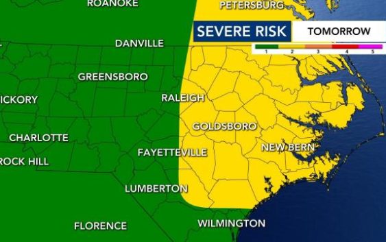
North Carolina will see some rain and severe weather this weekend not directly from Laura but from a cold front that the storm’s remnants will strengthen.
Friday is sticky and hot, with a high of 94 degrees, but it’s going to cool off on Saturday night. You’ll be able to feel it throughout the day on Sunday. Humidity will be low and highs will be in the mid 80s.
The center of the storm’s remnants are expected to pass just north of our state, but the southern section, which will cross over parts of NC on Saturday, is expected to have the greatest potential for severe storms.
As of Friday afternoon, Laura has lost many of its tropical characteristics and it is not very strong.

By Saturday afternoon, eastern areas of NC could expect 30 to 40 mph wind gusts, heavy rain and isolated tornadoes. The eastern half of North Carolina has a Level 2 risk for severe storms in place. The warning includes the eastern part of the Triangle as well.
WRAL meteorologist Aimee Wilmoth said scattered storms are most likely starting around 12 to 1 p.m.
Gardner said the heaviest rain may be closer to the Virginia line.
After the cold front passes, the Triangle will experience much milder temperatures, with temperatures in the mid 80s starting Sunday and for the new work week.
