- Sellers and Rantanen are among the NHL trade deadline winners. Hurricanes and Boeser are some losers
- Hurricane forecasters express concern over NOAA job cuts impact
- FEMA deadline for Hurricane Helene recovery aid extended again
- Tornado drills to take place at schools across North Carolina Friday morning
- Hays County emergency alerts cause confusion during Tuesday's wildfires
Level 2 risk for severe weather in place, chance of heavy rain and tornadoes
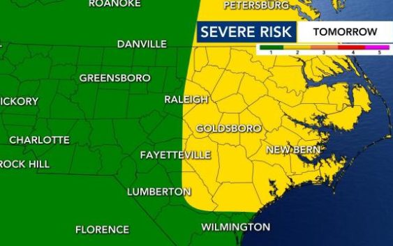
Eastern parts of North Carolina are under a Level 2 risk for severe weather on Saturday, and the entire state is under a Level 1 risk for severe weather.
We could see heavy rain, 40 to 50 mph wind gusts and isolated tornadoes on Saturday because of the storm. The severe weather risk is in place because of a cold front that is rolling in, which Hurricane Laura’s remnants are bringing us.
As this system has moved across the country has produced a lot of severe weather — including tornadoes and warnings.
From the I-95 corridor and eastward we have the greatest threat of severe weather, WRAL meteorologist Elizabeth Gardner said.

By 1 or 2 p.m. we will start to see the storms develop. Our temperatures right now are really warm — in the upper 80s.
Move your weekend plans to Sunday, said WRAL meteorologist Kat Campbell. Although Saturday has severe weather moving through, Sunday looks beautiful, with calmer and cooler weather. The heat and humidity will also begin to be much lower on Saturday heading into Sunday.

Sunday is shaping up to be a nice day with dry conditions and the lower humidity.
“Sunday looks great,” Campbell said. “So if you need to plan something outside, Sunday should be a sunny day and less humid, as well. So opt for Sunday for your weekend plans.”
