- Weather Impact Alert: Heavy rain could lead to flooding across Carolinas
- North Carolina legislators fleshing out details on $500M in additional Hurricane Helene relief
- Dangerous travel conditions: Ice, snow and flooding possible
- How photos lost in disasters like Hurricane Helene find their way home, with a little help from people who care
- Dangerous travel conditions, ice/snow and flooding possible in the mountains Tuesday and Wednesday
Triangle under flash flood warning

Raleigh, N.C. — Six counties, including the Triangle are under a flash flood warning until 9 p.m. Monday.
“This will likely cause some minor flooding, and it may be a little bit more noticeable in locations that tend to flood,” said WRAL meteorologist Mike Maze.
WRAL meteorologist Kat Campbell said most of the rain Monday has been from Johnston County and points west.
“We’ve been dryer for our eastern communities, but Rocky Mount, Wilson, Goldsboro — all of these storms are tracking to the east this evening, so you’re not out of the woods just yet,” said Campbell.
One of the key concerns is going to be urban flooding, where rapid rising in water levels that can make it dangerous for driving.
Maze said storms will be possible Monday until about midnight.
“They have a small potential to be severe, heavy rain which will cause some localized flooding. We’re already seeing out there right now,” he said.
Lightning, gusty winds and isolated tornadoes are possible from Raleigh westward.
Campbell said the northeastern part of th WRAL viewing area have the best chance of seeing a severe storm Monday night because it is closer to a warm front that is in southern Virginia.
“This is also where we cold a little bit of rotation as the storms move through,” explained Campbell.
A tornado warning issued for Mecklenburg, Va. expired at 7 p.m. Monday, but Campbell said there could still be a risk for severe weather.
“We’re watching this same storm cell though because as it continues to move to the southeast it could impact the northern part of North Hampton County,” said Campbell.
Download the WRAL Weather app to get weather alerts
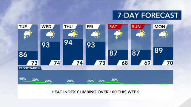
Storms are also in the forecast for Tuesday afternoon, but the rest of the week looks mostly clear.
Temperatures will be mildest on Monday and Tuesday, with highs in the mid to upper 80s. By Wednesday, temperatures will enter the 90s again and stay there for the rest of the week.
The region will experience above-normal weather for the first half of September, Gardner said. Paople will have to wait a bit longer to get get excited for fall weather, she said.
Tracking the tropics
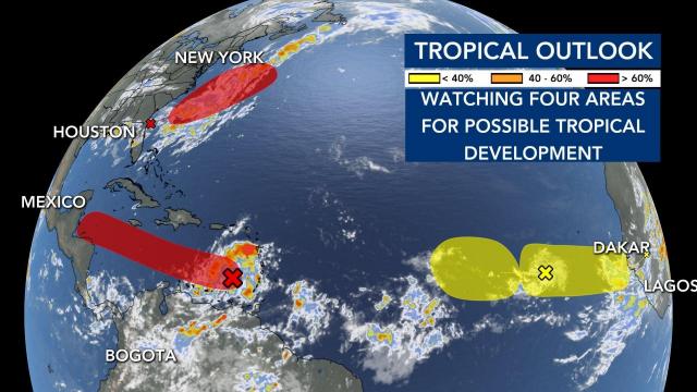
Meteorologists are tracking four areas in the tropics, though none poses a threat to North Carolina
According to WRAL meteorologist Peta Sheerwood, an area of low pressure will continue to develop off the coast of South Carolina. There is a 60% chance of development in the next two days. This system, however, will move away from the coast.
Gradual development will take shape in an area of low pressure over the eastern Caribbean Sea. A tropical depression will be possible in the next couple of days. Some models have this strengthening into a tropical storm as it moves westward to the Yucatan peninsula.
Finally, two tropical waves off the coast of Africa have a low chance of developing over the next five days.
Even though several storms have developed, the height of hurricane season doesn’t arrive until Sept. 10.

