- Seven months after Hurricane Helene, Chimney Rock rebuilds with resilience
- Wildfire in New Jersey Pine Barrens expected to grow before it’s contained, officials say
- Storm damage forces recovery efforts in Lancaster, Chester counties
- Evacuation orders lifted as fast-moving New Jersey wildfire burns
- Heartbreak for NC resident as wildfire reduces lifetime home to ashes
Tracking the tropics: Tropical Storm Nana forms but is steering away from the Gulf of Mexico
And Tropical Depression 15 is heading east away from the U.S. East Coast.
HOUSTON — The Atlantic hurricane season is still underway and still very busy.
As we look across the Atlantic Basin on this Tuesday, there are no immediate threats to the U.S. mainland or Texas coast. So we will get that good news out of the way quick.
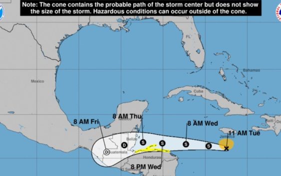
We have a tropical system (Tropical Cyclone 15 ) heading east into the Atlantic away from the U.S. and another (Potential Tropical Cyclone 16 which is now Tropical Storm Nana) in the Caribbean that is forecast to steer away from the Gulf of Mexico and head southwest. As of 11:20 a.m. Central time Nana had 50 mph winds, according to the National Hurricane Center.
In the far right on the below image you can also see the tropical wave we’ve been monitoring in Africa (the yellow X), but it has a 0% chance of development right now. So even more good news there.
Here is a look at the latest forecast cone, released at 10 a.m. Tuesday, on the system we were more closely watching in the Caribbean, Tropical Storm Nana:
Colder air sweeping south
Much of the U.S. is expecting much colder air to push southward by the second week of September. These cold fronts, if they make it all the way south, will help to steer away any dangerous tropical weather.
Make sure you download the KHOU 11 app to keep updated with the latest developments and forecast.