- Weather Impact Alert: Heavy rain could lead to flooding across Carolinas
- North Carolina legislators fleshing out details on $500M in additional Hurricane Helene relief
- Dangerous travel conditions: Ice, snow and flooding possible
- How photos lost in disasters like Hurricane Helene find their way home, with a little help from people who care
- Dangerous travel conditions, ice/snow and flooding possible in the mountains Tuesday and Wednesday
Tracking the tropics: Watching Tropical Storms Nana and Omar
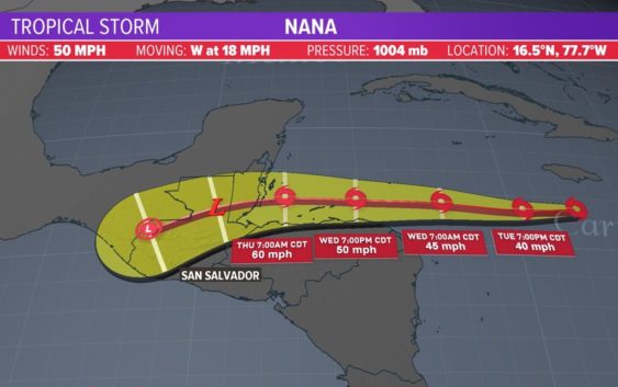
HOUSTON — The Atlantic hurricane season is still underway and still very busy.
As we look across the Atlantic Basin on this Wednesday, there are no immediate threats to the U.S. mainland or the Texas coast. So we will get that good news out of the way quick.
As far as any future disturbances go, NOAA is monitoring two additional waves – one in the Atlantic and the other off the coast of Africa, also heading into the Atlantic. Both have a low to moderate chance of development over the next few days. It is much too soon to know where these will go and how strong they will become. You can see these waves below in the yellow on the right: