- McDowell County wildfire spreads to 500 acres, evacuation orders in place
- Evacuations in Caldwell County due to wildfire
- Northwest Houston 'ghost neighborhood' caused by repeated flooding to become latest detention basin
- NHL playoffs: Hurricanes open playoffs Easter Sunday afternoon vs. Devils
- 2 wildfires spreading in rugged terrain in western North Carolina
Flash flood warning issued for San Antonio through Thursday as cold front, storms move into area

-
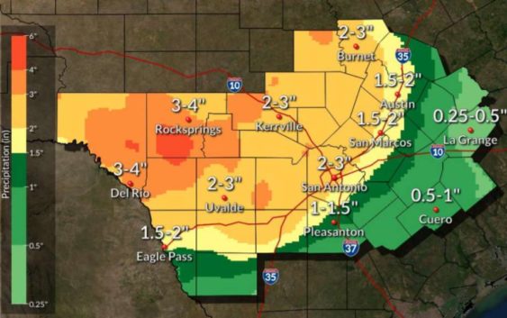
The National Weather Service has issued a flash flood watch for San Antonio as showers bring heavy rainfall through the area.
The National Weather Service has issued a flash flood watch for San Antonio as showers bring heavy rainfall through the area.
Photo: National Weather Service
The National Weather Service has issued a flash flood watch for San Antonio as showers bring heavy rainfall through the area.
The National Weather Service has issued a flash flood watch for San Antonio as showers bring heavy rainfall through the area.
Photo: National Weather Service
The National Weather Service has issued a flash flood watch for San Antonio until 1 p.m. Thursday.
Bouts of heavy rain are expected as a cold front moves into the area. The Alamo City could see up to 3 inches of rain through Thursday. Repeated rounds of showers and thunderstorms increase the likelihood of flash flooding in the area, meteorologists said.
The watch extends throughout South-Central Texas including counties such as Bexar, Blanco, Comal, Hays, Kendall, Kerr Medina, Travis and Williamson.
READ ALSO: Fast-moving storm cells formed late Tuesday over San Antonio, up to 1 inch rain possible NWS reports
An emergency alert was sent out to portions of San Antonio around 3 a.m. Wednesday and the watch, which was initially set to expire at 6 a.m. Wednesday, was extended twice before 8 a.m.
Current drought conditions will help lower chances of flooding, however flash floods could occur with any quick accumulation of heavy rainfall.
By 8 a.m., six San Antonio roads had been closed due to flooding: Maltsberger Lane, OP Schnabel, Pinn Road, Southwell and Vance Jackson at Orsinger. The storms also knocked out power for nearly 200 homes Wednesday morning.
There will also be a dip in temperatures. Wednesday’s high is only expected to be around 85. On Thursday, San Antonio’s high is expected to be 77.
Taylor Pettaway is a breaking news and general assignment reporter for MySA.com | taylor.pettaway@express-news.net | @TaylorPettaway