- Hays County emergency alerts cause confusion during Tuesday's wildfires
- Tuesday's wildfires scorched more than 500 acres in south Bexar County
- How big were this week's wildfires in Bexar County?
- Crews contain wildfire in southeast Williamson County
- Wildfire contained to 300 acres in northwest Matagorda County
Tropical Storm Sally takes shape off the Florida coast
The tropics have been exploding for the past several days.
Tropical Depression 19, which formed Friday off the coast of Florida, strengthened into Tropical Storm Sally on Saturday around 2 p.m. after emerging into the Gulf of Mexico. The Gulf of Mexico’s warm waters will likely continue to fuel the development of the storm.
Tropical Storm Sally is now off the coast of Florida, set to bring heavy rain to Florida Keys.
Thursday marked the peak of hurricane season in the Atlantic basin
None of the active systems in the tropics are forecast to impact North Carolina at this time, but there is plenty to keep an eye on.
A tropical wave over the Gulf of Mexico has a low chance of development over the next 5 days. Two tropical waves west of African have a medium to high chance of developing over the next 5 days.
Right now, Tropical Storms Rene and Paulette are moving northwest. Paulette is forecast to strengthen to a Category 2 Hurricane and strike Bermuda. We will feel light effects of Paulette on the coast, which will increase swells and our rip current risk.
There are just four storm names left on the World Meteorological Organization list for 2020. There are no storms that begin with Q, U, X, Y and Z, because there aren’t enough names with those letters.
Once the designated list of names for the season is used up, any additional storms get names from the Greek alphabet. The only time that has happened was in 2005, to date the busiest hurricane season on record, when there were 28 named storms.
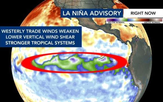
La Niña means hurricanes more likely through fall
The Climate Prediction Center on Thursday upgraded the United States from a watch to advisory status for La Niña conditions.
When cooler waters develop over the east-central Pacific, it decreases the wind shear in the Atlantic, making conditions there more hospitable for tropical systems to develop into hurricanes.