- Weather Impact Alert: Heavy rain could lead to flooding across Carolinas
- North Carolina legislators fleshing out details on $500M in additional Hurricane Helene relief
- Dangerous travel conditions: Ice, snow and flooding possible
- How photos lost in disasters like Hurricane Helene find their way home, with a little help from people who care
- Dangerous travel conditions, ice/snow and flooding possible in the mountains Tuesday and Wednesday
Brisk fall temperatures, rain from Tropical Storm Sally all on tap this week
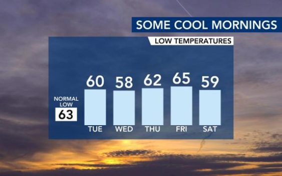
Raleigh, N.C. — A cold front Monday afternoon will bring us some rain and cool mornings.
According to WRAL meteorologist Aimee Wilmoth, it will be warm ahead of the front, with highs in the mid 80s Monday. A few showers or storms are possible later this afternoon or evening possible as the front moves in.
Track rain in our area with the DualDoppler5000
On Tuesday and Wednesday, it will feel more like fall, with drier air, sunshine and highs in the upper 70s.
By Thursday and Friday, remnants from Tropical Storm Sally could bring some rain to our area. Wilmoth said Sally will likely make landfall early Tuesday morning along the southeastern coast of Louisiana as a Category 1 hurricane.

“Hurricane warnings are in place along parts of the Louisiana coast to parts of the Alabama coast,” Wilmoth said. “Storm surge warnings are also in place. Sally will be a slow-mover, potentially bringing 8 to 16 inches of rain along the Gulf Coast.”