- How photos lost in disasters like Hurricane Helene find their way home, with a little help from people who care
- Dangerous travel conditions, ice/snow and flooding possible in the mountains Tuesday and Wednesday
- Weather Impact Alert: Dangerous travel conditions, ice/snow and flooding possible in the mountains Tuesday and Wednesday
- North Carolinians perplexed by unexpected DMV refunds tied to Hurricane Helene relief
- Yes, NCDOT is sending Hurricane Helene relief checks
Hurricane Sally expected to strengthen into Category 2 storm as it approaches Gulf Coast

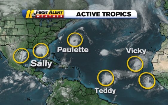
The National Hurricane Center now sees several tropical waves in the Atlantic storm basin.
Tropical Storm Sally remains a hurricane headed for the Gulf Coast on Tuesday morning, though it was downgraded to a Category 1 storm at 2 a.m. Sally’s winds are up to 90 mph with 120 gusts.
Sallys is expected to strengthen to a Category 2 as it approaches land on Tuesday. It was 75 miles east-southeast of the mouth of the Mississippi River at 2 a.m. and moving west at 3 mph.
The slow-moving system could dump tons of rain in its path.
Sally is expected to bring extremely dangerous and life-threatening storm surge. Storm surge warnings have been issued from Port Fourchon in Louisiana to the Mississippi/Alabama border.
Hurricane conditions are expected early Tuesday in southeastern Louisiana and later that night along Mississippi, Alabama and Florida Panhandle. The NHC said it’s still too early to determine where Sally’s center will move onshore.
Sally is the earliest “S” storm in recorded history.
Tropical Storm Sally will likely become a hurricane later today or tonight. A cold front plus moisture from Sally’s remnants will bring rain to central North Carolina Thursday. pic.twitter.com/oBO09Stgrh
— Brittany Bell (@BrittanyABC11) September 14, 2020
On Monday morning, Tropical Storm Vicky formed west of the Cabo Verde Islands. It is not expected to cause a serious impact and will be short-lived. Vicky is the 20th named storm of the season and currently the fifth named storm in the Atlantic.
Preparing your hurricane kit during COVID-19
Out in the Atlantic, Hurricane Paulette is moving northwest at 13 mph with maximum sustained winds of 90 mph.
The eye and eyewall of Paulette is over Bermuda on Monday morning.
After hitting Bermuda, the storm is expected to turn north and stay away from the United States. Swells from Paulette are expected to impact parts of the Leeward Islands, the Greater Antilles, the Bahamas, Bermuda and the southeastern United States.
Tropical Storm Teddy was named on Monday morning after forming off the west coast of Africa. Teddy is moving west-northwest at 14 mph with maximum sustained winds of 40 mph. Teddy could become a major hurricane, possibly a category 3, later in the week.
Tropical Storm Teddy will likely strengthen to a hurricane late Tuesday or Wednesday. It’s forecast to become a major hurricane, category 3, by the end of the week. pic.twitter.com/PCT1uqMJ9u
— Brittany Bell (@BrittanyABC11) September 14, 2020
Rene is currently a tropical depression out in the Atlantic Ocean moving northwest at 6 mph with maximum sustained winds of 30 mph.
What happens when we run out of letters of the alphabet for hurricane names?
A tropical wave off Africa’s west coast has a 30 percent chance of development over the next 48 hours. Another wave in the Gulf has a 10 percent chance of development in the next 48 hours.
The next storm to become a tropical storm will be named Wilfred, the final name before moving on to the Greek alphabet. Here’s what happens if we run out of names.
The last time that happened was 2005–which is the current record holder for the most active hurricane season ever.
Copyright © 2020 WTVD-TV. All Rights Reserved.