- One set of evacuation orders lifted in Caldwell County after wildfire contained
- 'We gutted every building' | Chimney Rock rebuilding after Hurricane Helene
- 'We gutted every building' | Chimney Rock rebuilding after Hurricane Helene
- Debris from Hurricane Helene provides fuel, complicates containment for spring wildfires
- David & Nicole Tepper increase Hurricane Helene relief commitment to $750k
Hurricane Sally downgraded, still poised to dump lots of rain in North Carolina Thursday and Friday

The center of Sally is 50 miles southeast of Montgomery, Alabama, at 5 a.m., although the bands from the storm have already arrived in North Carolina. Sally will work through Georgia on Thursday morning and continue through the Carolinas on Friday. It will pick up speed, preventing us from getting the massive rainfall totals that Florida and Alabama got.
ABC11 is in First Alert Mode for the severe weather risk for Thursday. The southeastern part of our viewing area is under a level 2 risk for severe weather on Thursday with the biggest threat being localized flooding and damaging winds.
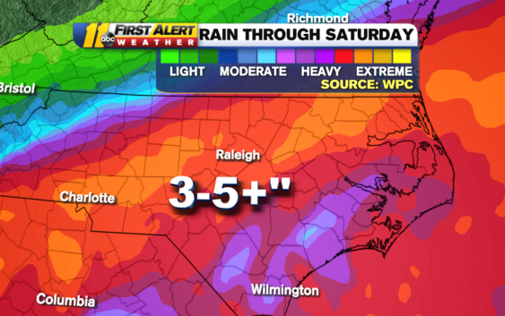
The Weather Prediction Center, a branch of the National Weather Service, predicted 3 to 5 inches of rain for our area through Saturday.
Cumberland and Sampson counties are under a level 2 risk for severe weather as are parts of Johnston and Harnett counties. Everyone will see heavy rain as the entire area is under a Flash Flood Watch through Friday.
Not only could flooding become a concern in the next 24 hours, part of our area under a CAT 2 risk for severe weather. Biggest threat=damaging wind. #ncwx pic.twitter.com/WX31nnPja6
— 𝘿𝙤𝙣 𝙎𝙘𝙝𝙬𝙚𝙣𝙣𝙚𝙠𝙚𝙧 (@BigweatherABC11) September 17, 2020
The heaviest rainfall Thursday will be between 2 p.m. and 7 p.m., so be careful on the drive home. The storm will become an area of low-pressure Thursday night.
Temperatures on Friday will stay in the low to mid 70s. We’ll clear out over the weekend with highs near 70. We’ll remain dry through the start of fall on Tuesday.
Copyright © 2020 WTVD-TV. All Rights Reserved.